A First Look at JPSS-1/NOAA-20 ATMS
December 8, 2017 07:08 AM
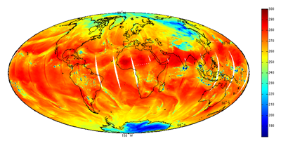
Figure 1: NOAA-20 ATMS Channel 18 Antenna Temperature
© NOAA
The JPSS-1 satellite was launched on November 18, 2017 as a follow-on to the Suomi-NPP satellite (itself launched over 6 years ago). The first data from the Advanced Technology Microwave Sounder (ATMS) instrument was received 11 days later on November 29.
CICS-MD Scientist Hu Yang and his ATMS Sensor Data Records (SDR) Team processed the raw data from the satellite. The figure above shows the ATMS brightness temperature of channel 18 at 183.31 ± 7 gigahertz (GHz). Blue colors depict areas with less water vapor, while green-yellow-red colors represent abundant water in all phases (vapor, clouds, and precipitation) in low and middle latitudes. Blue in the polar region depicts surface snow and ice.
CICS-MD Scientist Chris Grassotti and his colleagues began processing the new ATMS data almost immediately through the Microwave Integrated Retrieval System (MiRS). The images below show a comparison of MiRS retrieved total precipitable water (TPW) from both the NOAA-20 and S-NPP satellites.
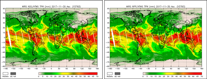
Figure 2. MiRS N20 (left) and SNPP (right) ATMS retrievals of total precipitable water (TPW) on 30 November 2017.
It is clear that the retrievals are remarkably consistent. The work of calibration and validation is now underway to optimize and validate the retrieval performance from the new satellite.
Many more NOAA-20 "firsts" are on the way!
« Back