CISESS Seed Grant: Developing High Spatiotemporal Resolution Vegetation Datasets from Multi-Sensor Satellite Observations for Enhanced Ecological and Agricultural Monitoring
April 14, 2025 11:06 AM
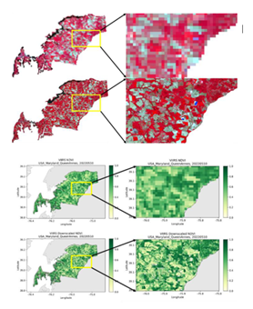
Figure: A preliminary case study in Queen Anne’s county, Maryland: a) comparison between original VIIRS image at 1km resolution and integrated image at 20m resolution; and b) the corresponding NDVI comparison.
© NOAA/NESDIS/STAR
Yuan Zhou, Assistant Research Scientist, UMD/ESSIC/CISESS
Satellite-based vegetation datasets such as Vegetation Indices (VI) and Green Vegetation Fraction (GVF) are essential for monitoring vegetation health, understanding ecological changes, and supporting precision agriculture. However, existing products face trade-offs between spatial and temporal resolution. Coarse-resolution sensors like VIIRS offer frequent global coverage but lack fine detail, while high-resolution satellites such as Sentinel-2 and Landsat provide detailed imagery but with infrequent revisits. This limits their utility for near-real-time agricultural and ecological monitoring, particularly during critical growth periods or rapidly changing environmental conditions. Addressing these limitations is crucial for enhancing food security, supporting sustainable agriculture, and monitoring ecosystem dynamics.
This CISESS Seed Grant Project aims to overcome the spatial-temporal trade-offs by integrating multi-sensor satellite data to develop high spatiotemporal resolution vegetation datasets. Key objectives include: 1) Designing a hybrid framework that combines coarse-resolution VIIRS data with high-resolution Sentinel-2 and Landsat imagery. 2) Pre-calibrating an offline look-up table (LUT) to eliminate dependency on real-time high-resolution data, ensuring efficiency and scalability. 3) Validating the framework using ground measurements for accuracy across diverse landscapes. 4) Producing daily vegetation datasets at 10–30m resolution to support precision agriculture and ecological monitoring. 5) Preparing the framework for operational deployment within NOAA systems to provide consistent, high-quality vegetation products.
Our project will deliver: 1) Daily high-resolution vegetation datasets (10–30m). 2) A pre-calibrated LUT for seamless integration of satellite observations. 3) A framework ready for operational deployment, aligning with NOAA's mission to deliver actionable Earth observation data. A preliminary effort has been conducted to test the feasibility of the proposed method. The Figure above shows a case study in Queen Ann’s county, Maryland, dominated by cropland. The integrated image and the Normalized Difference Vegetation Index (NDVI) map reveal significantly enhanced spatial details compared to their counterparts at the original 1km resolution.
With the successful completion of this project, these datasets will enhance precision agriculture, contribute to sustainable resource management, and improve resilience to environmental challenges, offering tangible benefits to ecological and agricultural stakeholders.
« Back