How to Monitor Coastal Water Quality from Satellites
April 14, 2025 02:19 PM
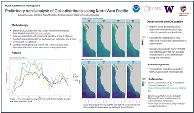
Figure. A participant’s Tier II data analysis project to monitor changes in chlorophyll-a (Chl-a) in the Pacific Northwest using temporal trends and spatial distributions.
© NOAA CoastWatch
Ron Vogel, Senior Faculty Specialist, UMD/CISESS/ESSIC
In April 2025, CISESS Scientist Ron Vogel taught a week-long class for water quality management professionals entitled “Viewing and Analyzing Ocean/Coastal Events and Water Quality Using Satellites”. The class aimed to expand the use of oceanographic satellite data for monitoring conditions in coastal areas, such as toxic algal blooms and water clarity that affect human health, the aquaculture industry, tourism, and recreation.
Vogel, teaching with colleagues at NOAA CoastWatch, offered the class in two tiers, so participants could have the flexibility to gain the skills most relevant to incorporate satellite data into their work. Tier I introduced participants to data visualization tools, such as ArcGIS, the NOAA CoastWatch Data Analysis Tool, and NOAA’s online Environmental Research Division’s Data Access Program data visualization server. In Tier II, participants learned to work more programmatically and analytically with satellite data and worked on a mini research project, drawn from their own work, which they presented at the end of the course.
Tier I was attended by 45 participants, with 20 continuing to Tier II. Participants came from a range of federal and state agencies, including the U.S. Coast Guard, NOAA, the Connecticut Bureau of Aquaculture, the Connecticut Department of Energy and Environmental Protection, and the New York State Department of Environmental Conservation. There were also participants from universities, including the City College of New York, the University of Maryland Center for Environmental Science, and Oregon State University.
A feedback survey highlighted an increase in participants' confidence and likelihood of using satellite data following the course. One class member shared this overall comment: “Going through this course has been an incredibly valuable opportunity! The course gave me a baseline understanding of satellite data and how to access, display, and analyze it. I am excited to incorporate satellite data into my projects!”
As a CISESS Scientist, Vogel works with NOAA colleagues to apply the nation's satellite observations to society's economic, health and safety needs, thereby maximizing the nation's investment in satellite resources.
Important Links:
NOAA CoastWatch: https://coastwatch.noaa.gov/cwn/index.html
CoastWatch Learning Portal: https://umd.instructure.com/courses/1336575
From: Maureen Cribb, CISESS Report to NOAA for 11 April 2025.
« Back