NOAA Knows Remote Sensing of Precipitation
July 28, 2017 08:43 AM
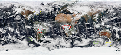
Suomi NPP color composite visible imagery for 17 February 2017 highlights deep convection clouds (red), cellular convection (green) and stratiform clouds (yellow).
© Elsevier
SCSB Chief Ralph Ferraro is the lead author of the first chapter in a new volume on the Water Cycle, part of the nine-volume set on Comprehensive Remote Sensing to be released by Elsevier. His chapter covers remote sensing of precipitation and includes information on:
o Visible and Infrared Methods;
o Passive Microwave Methods;
o Active Microwave Methods;
o Multisensor Datasets; and
o Drought and Flood Applications.
UMD Professor and CICS-MD Scientist Shunlin Liang is the Editor in Chief of the series. Elsevier plans to release the books in November 2015. They are available for pre-order at https://www.elsevier.com/books/comprehensive-remote-sensing/liang/978-0-12-803220-6. Ferraro, Ralph, Gail Skofronick-Jackson, Yang Hong, and K. Zhang, Chapter 1: Precipitation, in Volume 4: Remote Sensing of Hydrological Cycle (ed. Jiancheng Shi) of Comprehensive Remote Sensing (9 Vols., Elsevier, in press).
« Back