CICS Support for the National Centers for Environmental Information (NCEI): Pathfinder Sea Surface Temperature (PFSST), Ocean Surface Salinity Investigation (OSSI), Ocean Color Reprocessed Data (OCRD), and Jason 3 Stewardship Archive
Research Topic:
Climate Data & Information Records/Scientific Data Stewardship
Task Leader:
Sheekela Baker-Yeboah
CICS Scientist:
Sheekela Baker-Yeboah, Korak Saha, Yongsheng Zhang & Xiaoyan Li
Sponsor:
NESDIS NCEI
Published Date:
9/26/2017
2017 ANNUAL REPORT
CICS-UMD NOAA/NESDIS/NCEI Staff: Dr. Sheekela Baker-Yeboah, PI/Co-PI for Satellite Team Projects and Team Lead ( NOAA Collaborators: Dr. Krisa Arzayus, Dr. Paul DiGiacomo, Dr. Eric Bayler, Dr. Eileen Maturi, Dr. Alexander Ignatov, Dr. Robert Evans, Dr. Eric Leuliette, Dr. Kenneth S. Casey, Dr. Huia-min Zhang, Dr. Laury Miller, Dr. Menghua Wang, Dr. David Donahue); Dr. Korak Saha (NOAA Collaborators: Dr. Kenneth S. Casey, John Relph, Thomas Ryan, John Sapper, Dr. Alexander Ignatov, Dr. Frank Monaldo, Christopher Jackson, Dr. Gang Liu, Dexin Zhang); Dr. Yongsheng Zhang (NOAA Collaborators: Dr. Eric Bayler, Dr. Banghua Yan, David Donahue, John Lillibridge).
Background
NOAA's National Centers for Environmental Information (NCEI) is an integration of NOAA/NESDIS National Data Centers in Asheville, NC; Boulder, CO; Stennis, MS; and Silver Spring, MD to provide access to the world's most comprehensive environmental data. The Silver Spring, MD location was formerly known as the National Oceanographic Data Center (NODC). NCEI is composed of two main centers: the Center for Weather and Climate; and the Center for Coasts, Oceans, and Geophysics (http://www.ncei.noaa.gov/). NCEI hosts and provides public access to over 20 petabytes of comprehensive atmospheric, coastal, oceanic, and geophysical data. NCEI provides scientific and public stewardship for the nation’s environmental data, maintains and updates archives of these data, and contributes scientific research and produce products from these data that help monitor global environmental changes. In January 2017, Dr. Xiaoyan Li joined the CICS-MD team at NCEI to work with Dr. Sheekela Baker-Yeboah, Dr. Krisa Arzayus, and Dr. Kenneth Casey on the NSF Arctic Data Center Project.
The NCEI Ocean Satellite Team consists of CICS members Dr. Sheekela Baker-Yeboah (Team Lead), Dr. Korak Saha, andDr. Yongsheng Zhang, and are responsible for the product development and scientific stewardship of ocean satellite data into the archive. The Satellite Team work on product generation and closely with the NOAA/NESDIS Center for Satellite Applications and Research (STAR) to archive satellite data. These include Jason altimetry, Satellite Sea Surface Salinity, Sea Surface Temperature, Synthetic Aperture Radar, VIIRS (Visible Infrared Imager Radiometer) Ocean Color products, and Satellite Ocean Heat Content Suite, all derived from the variety of satellite platforms.
NCEI serves as the authoritative source within the US for the near real-time and delayed-mode Ocean Surface Topography Mission (OSTM) Jason-2 and Jason-3 products, distributing them to the scientific community as well as the public at large. In addition to providing rigorous long-term archival services, NCEI provides high-level data stewardship with development of custom and routine satellite data products and data visualizations.
CICS-NCEI Satellite Team Members also develop products for scientific applications. Example products include Coral Reef Temperature Anomaly Databased (CoRTAD) and Pathfinder 4km Sea Surface Temperature Climate Data Record. The satellite team works collaboratively with the NCEI Data Stewardship Division to make these data discoverable, perform quality assurance, and provide scientific and technical support to users of these data (http://www.nodc.noaa.gov/SatelliteData/). The ongoing satellite data products are all automatically ingested and placed in the NCEI public data archive. Here they are made available to the public with an array of access mechanisms including ftp, http, OPeNDAP, THREDDS and our geoportal.
The CICS-NCEI Satellite Team produces the Pathfinder Sea Surface Temperature Climate Data Record. Global sea surface temperature (SST) fields are important in understanding ocean and climate variability. The NOAA National Centers for Environmental Information (NCEI) develops and maintains this high-resolution, long-term, climate data record (CDR) of global satellite SST. These SST values are generated at approximately 4 km resolution using Advanced Very High Resolution Radiometer (AVHRR) instruments aboard NOAA polar-orbiting satellites going back to 1981. The Pathfinder SST CDR is recognized and utilized by users as an authoritative source of SST and contributes to the international effort on quality controlled SST field through GHRSST. This CDR is a primary source of information for numerous regional and global marine resource efforts (e.g., local habitat characterization, coral reef stress monitoring by Coral Reef Temperature Anomaly Database).
Another product produced by the Satellite Team is the Coral Reef Temperature Anomaly Database (CoRTAD) designed to quantify global-scale stressors that are widely deemed responsible for the decline of coral reefs. A likely candidate is rising sea surface temperature (SST) in much of the tropics. CoRTAD, funded in part by the NOAA Coral Reef Conservation Program, uses SST from NOAA’s Pathfinder program to develop weekly SST averages, thermal stress metrics, SST anomalies (SSTA), SSTA frequencies, SST Degree heating weeks and climatologies (http://www.nodc.noaa.gov/SatelliteData/Cortad/).
Accomplishments
The University of Maryland CICS Researchers continue to enhanced NOAA’s abilities to understand, predict and communicate climate variability by data dissemination, public education and product development. Product development and scientific archival stewardship of Satellite Data are summarized by projects: SBSB_OSSD_16 - Ocean Satellite and Surface Data Stewardship, SBSB_ODAT_16 - Ocean Data Stewardship, SBSB_OPPA_16 - NOAA Jason 3 Stewardship Archive, SBSB_OCRD_16 - VIIRS Ocean Color Reprocessed Data Stewardship.
Ocean Satellite and Surface Data Stewardship
1. Pathfinder Sea Surface Temperature (SST) development and stewardship
a. CICS Research Scientist Dr. S. Baker-Yeboah and CICS Postdoctoral Research Associate Dr. K. Saha continue to maintain ongoing updates to this suite of products. Version 5.3 recent updates to the L2P and L3U products (version 5.3.1). Ongoing efforts are to port these data onto Amazon Web Services for long term access and discovery. Dr. Baker-Yeboah is the project PI who worked collaboratively with team members Dr. Saha and Mr. Dexin Zhang to generate and steward these products. They are working on the manuscript (Baker-Yeboah, S., K. Saha, D. Zhang, K. S. Casey, K. A. Kilpatrick, R. Evans, and Thomas Ryan. “Pathfinder Version 5.3 AVHRR Sea Surface Temperature Climate Data Record’’). Dr. Baker-Yeboahgave a poster presentation on PFSST at the AGU 2016 Meeting San Francisco, California.
b. Pathfinder version 5.3.1 for L2P and L3U data was updated from the version 5.3 after some minor codes changes were applied. These code changes were made to account for swath drops and avoid missing navigational files. The L2P and L3U data is regenerated and is being quality monitored for archiving. The quality monitoring includes generating images (Figure 1) for each swath using the Python code and visually inspect them.
c. Coefficient updates for the next version of Pathfinder - A match-up database (MDB) is generated between L2P SST and iquam-2 in-situ SST for one sample year (2014). Work is undergoing to develop, maintain and use codes to generate the coefficients going forward.
d. Automation process for archival of Pathfinder 5.3 L3C data was developed, in September 2016 the 33 years (1981-2014) of data was archived and collection and granule level metadata are developed.
e. Pathfinder version 5.3 L3C Archival process started with data quality monitoring and validation against the in-situ observations (Figure 2). Dr. Korak Saha generated the codes in IDL to develop a matchup database (MDB) using L3C pathfinder data against the iQuam2 insitu SSTs. Daily global statistics as well their monthly and yearly counterparts are also generated. These global statistics were part of the L3C validation process.
2. Synthetic Aperture Radar (SAR) Wind archive implementation
a. New SAR data for Sea Surface Wind from Sentinel-1A and Sentinel-1B produced by NOAA STAR is getting archived using an automation process that was developed with the help of DSD and SEB branches of NCEI. Dr. Baker-Yeboah worked collaboratively between NCEI and STAR with Dr. Saha on this project to champion these data into the NCEI archive.
b. Dr. Baker-Yeboahprovides subject matter expertise as a Physical Oceanographer and manages the project.
c. Figure 3 (a-b) shows an archived image of wind data from Sentinel-1A and Sentinel-1B.
d. Dr. Korak Sahaworked with DSD to generation granule metadata and discovery through NCEI Geoportal, collection metadata is ready but is not yet indexed with the granule metadata.
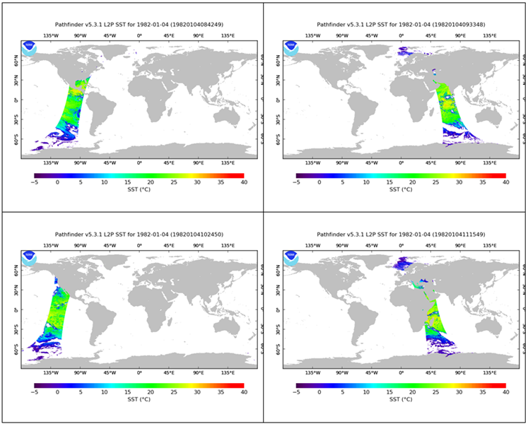
Figure 1. Pathfinder Sea Surface Temperature level 2 processed (L2P) data to be published to the public via the NOAA archive for the first time.
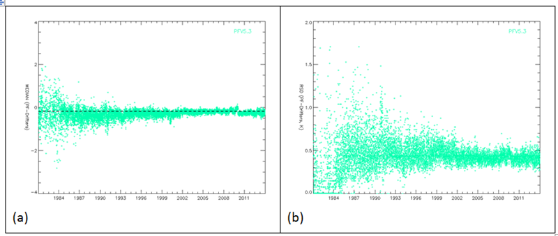
Figure 2. Pathfinder 5.3 L3C Match-up database with in-situ SSTs are used to generate global median (a) and robust standard deviation (b) statistics on the difference field.
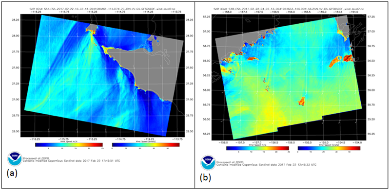
Figure 3. Archived images of SAR wind data obtained from Sentinel-1A (a) and Sentinel-1B (b).
1. Coral Reef Watch Daily 5 km Satellite Coral Bleaching Thermal Stress Monitoring Product
a. Dr. Korak Saha provided scientific stewardship for the STAR Coral Reef Watch (CRW) 5 km data. Data samples was checked for netCDF compliance and necessary suggestions were made to the producer for changes in the metadata.
b. CRW automation procedure is started by developing a archive documentation and finalizing the directory structure and archival procedure.
2. GHRSST Stewardship
NCEI has a Long Term Stewardship and Reanalysis Facility (LTSRF) for the Sea Surface Temperature Products as part of the Group for High Resolution Sea Surface Temperature (GHRSST). GHRSST is one of the dataset chosen to be served using NOAA’s OneStop Data Discovery and Access Framework Project, initialized in FY15 and is now working rapidly to improve discovery and access to NOAA's data.
a. CICS team members Dr. Baker-Yeboah and Dr. Saha contribute to the international effort on sea surface temperature call the Group for High Resolution Sea Surface Temperature (GHRSST: https://www.ghrsst.org).
b. Dr. Baker-Yeboahis a Co-PI on the NCEI GHRSST project and worked collaboratively with NCEI staff and Dr. Saha on this project. Dr. Baker-Yeboah presented a talk and posters at the GHRSST June 2016 meeting on the NCEI GHRSST data sets, Pathfinder SST GHRSST products and the Scientific Stewardship of GHRSST Products. Dr. Saha presented a poster on the level 3C product validation for the Pathfinder SST GHRSST products.
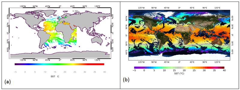
Figure 4. Two of the newly added GHRSST products in LTSRF; (OSI SAF) L3C SST data from SEVIRI on MSG-3 (a) and NOAA L3U SST product from VIIRS_NPP (b)
a. Dr. Korak Sahaworked with the DSD to generate granule level metadata for some of the GHRSST products archived last year. These data include Ocean and Sea Ice Satellite Application Facility (OSI SAF) L3C SST data from SEVIRI on MSG-3(Figure 8a), NOAA Office of Satellite and Product Operations (OSPO) L2P (Figure 8b) and L3U SST products from VIIRS_NPP.
b. Regular maintenance of GHRSST archived data. Annual GHRSST archive updates on provider information and other metadata updates performed for the GHRSST science team meeting. Troubleshoot related with daily automatic archival of all the products is regularly done, along with that helping out users of the GHRSST data by providing them information on the data.
c. Direct Archival of SST data from the producers (NCEI as GHRSST RDAC)
i. As a part of preparation for the multi-GDAC idea that is being proposed in last GHRSST meeting, the NOAA/STAR generated ACSPO AVHRR GAC SST data is served directly to NCEI. NOAA CoastWatch is the data provider (RDAC) and NCEI will be the GDAC and will also archive this retrospective data set (2002-current).
ii. After request was received to archive this data, an ATRAC appraisal request form was generated for NCEI. The satellite members are involved in getting this data archived starting from generating the ATRAC form to develop automation process to archive and/or access this data for the public usage.
Ocean Data Stewardship
1. Sea Surface Salinity (SSS) product development and stewardship
a. CICS Research Scientists Dr. Baker-Yeboah and Dr. Zhang work collaboratively on the Sea Surface Salinity investigation in collaboration with Dr. Eric Bayler of STAR. They are working on a manuscript (Zhang, Yongsheng, Eric Bayler and Sheekela Baker-Yeboah, 2016: NCEI Binned level-3 Aquarius and SMOS sea surface salinity datasets; in preparation and to be submitted to Data Science Journal). Dr. Baker-Yeboah provides subject matter expertise as a Physical Oceanographer and manages the project.
b. Dr. Zhang worked to development of NCEI-binned level-3 sea surface salinity data. He generated gridded level-3 SSS data from Soil Moisture Active Passive (SMAP) satellite level-2 granules by applying data quality flags and simple interpolation method. The outputs cover various time scales from swath to 8-day and monthly means.
Dr. Zhang gave a poster presentation on satellite sea-surface salinity data validation using NCEI real-time and delay-mode in situ observations at the December 2016 AGU meeting in San Francisco, CA.
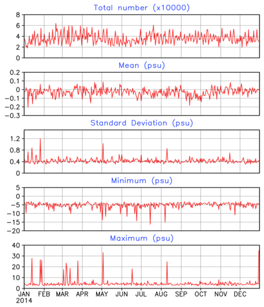
Figure 5. Daily statistical time series of SSS difference (SMOS roughness Model #1 minus co-located in situ GTSPP). From top to bottom: a) number of observations; b) global average; c) standard deviation; d) minimum and e) maximum. The data is matched within a 50-km footprint, centered at the SMOS Level-2 (swath) observation longitude and latitude values, and within a 3-day time window from -1 to +1 day.
a. Dr. Zhang worked to development of NCEI data quality monitoring systems (DQMS) on the level-2 sea surface salinity (SSS) swath data from the ESA’s Soil Moisture Active Passive (SMOS), NASA’s Aquarius and SMAP satellites. An important component of NCEI’s data stewardship for SSS satellite products is to develop the DQMS based on NCEI’s Rich Inventory conception in order to monitor and track the data assurance statistics and metadata attributes in each granule. In the last year, Dr. Zhang worked to establish and operationally implement of data quality monitoring on the latest version of level-2 SSS products from SMOS and Aquarius satellites, as well as those from SMAP satellite. The results are published on the NCEI SSS data quality monitoring homepage:http://www.nodc.noaa.gov/SatelliteData/sss/.
b. Dr. Zhangvalidates the NCEI-created binned SMOS V3.0 3-day and monthly mean, Aquarius (ADPS V4.0 and CAP V4.0) 7-day and monthly SSS products.
c. Dr. Zhangalso worked on development of NCEI scientific data validation system on the satellite SSS data by using NCEI-collected conventional ship observations. This includes development of the satellite-in situ SSS matchup datasets and to establish the web-based satellite SSS validation system. Dr. Zhang applied the SSS observations from NCEI-collected Global Temperature and Salinity Profile Programme (GTSPP) and Global Thermosalinograph (TSG) Database to generate the satellite-in situ matchup datasets, and initiated to investigate the results.
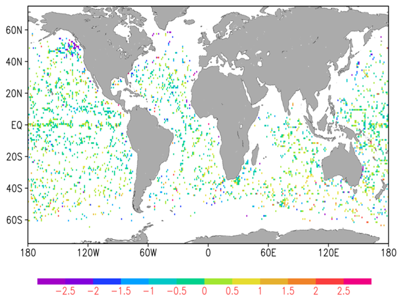
Figure 6. Global map of monthly mean SSS difference between SMOS (roughness Model 1) and co-located GTSPP in situ observations for March 2014. The data are matched within a 50-km footprint and within a 3-day time window. The matchup SSS differences are binned into a global 1-degree grid for determining monthly means.
NOAA Jason 3 Stewardship Archive
1. Dr. Baker-Yeboahprovides subject matter expertise as a Physical Oceanographer and manages the project. Dr. Zhang is the Science Steward of the NCEI Jason Stewardship project. Dr. Baker-Yeboah participated in the Ocean Surface Topography Science Team (OSTST) meetings during the early launch period and planning of the Jason mission, presented on the combined effort of NCEI to support the Jason mission at the OSTST meeting in La Rochelle France and ondecomposing the Sea Surface Height signal at the NASA Sea Level Change Team (N-SLCT) Meeting in Norfolk, Virginia. Dr. Zhang is also a member of the OSTST and has continued to work with NCEI staff to keep the Jason stewardship efforts going smoothly.
2. Implemented routine data archive, access and distribution tasks for Jason-2 and Jason-3 products. The CICS-NCEI Satellite Team members, Dr. Baker-Yeboah and Dr. Zhang, works collaboratively with the Jason-3 Team to provide public access to the Jason-3 level-2 X-GDR datasets and work with CLASS to archive the new data and work with STAR on providing more user products.
Dr. Zhanggenerated the data quality monitoring on the Jason-3 level-2 final and Interim Geophysical Data Record (GDR/IGDR) data files in order to monitor and track the data quality assurance and metadata attributes in each granule and made them available as part of a data discovery system. He also generated quick-look gridded datasets GDR/IGDR (cycle mean, 0.25x0.25 and 3.0x1.0 longitude/latitude degree ) for public users in near real-time. Dr. Zhang also coordinated NCEI’s archival work with NOAA and CNES data centers and perform monthly and annual reconciliation of Jason2/3 products archive between the two data centers.
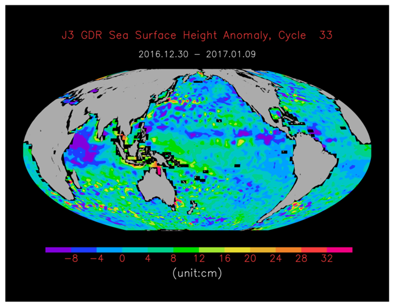
Figure 7. Cycle mean Sea surface height anomaly (in unit of) cm from NCEI-produced quick-look level-3 data from Jason-3 final Geophysical Data Record (GDR).
VIIRS Ocean Color Reprocessed Data Stewardship
1. Development of a new NCEI VIIRS Ocean Color science quality data access system
a. CICS Research Scientists Dr. Baker-Yeboah worked with NOAA data producer and NCEI Data Stewardship Division (DSD) in collaboration with the NOAA Complex Large Array-Data Stewardship System (CLASS)to develop a new NCEI VIIRS Ocean Color science quality data access system in connection with new enterprise efforts within NCEI. Dr. Baker-Yeboah and Dr. Zhang have helped to complete necessary archival documents between NCEI, STAR/CoastWatch (the data producer) and CLASS.
b. Dr. Baker-Yeboah continues to work with NCEI staff to move forward the repurpose of an OpenStack Cloud hardware system in connection with new enterprise efforts within NCEI and the development of collection.
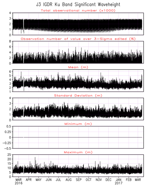
Figure 8. Jason-3 data quality assurance statistics in each granule (pass) for significant wave height of Jason-3 Interim Geophysical Data Record (IGDR)
a. Dr. Zhangwill work with NCEI staff on the granule-level metadata to improve the data search and discovery of ocean color environmental data records.
b. Dr. Baker-Yeboahprovides subject matter expertise as a Physical Oceanographer and manages the project.
PlannedWork
University of Maryland CICS Researchers plan to continue contributing to the NOAA mission for longterm access and discovery of Oceanographic Satellite Environmental information to support our Nation. Future efforts are summarized below.
1. Pathfinder SST product development and archive
a. Working towards validation statistics for the L2P and L3U products
b. Development of process to generate the SST Coefficients for future pathfinder versions
c. Work on a Amazon Web Services (AWS) Project to serve PFSST data (L2P, L3U, L3C)
2. Synthetic Aperture Radar (SAR) wind data archival stewardship
a. Scientific stewardship of Sentinel SAR-wind data
b. Stewardship of upcoming data from newer satellites
3. GHRSST Stewardship (pending NOAA funding)
a. Ongoing Data Stewardship for the GHRSST data set
b. Continue working as a Subject Matter Expert (SME) for the GHRSST products in NOAA OneStop
c. Complete and support archival of ACSPO AVHRR GAC L2P SST retrospective products.
d. Continue work on including and stewarding new GHRSST products that is added to the GHRSST LTSRF.
e. Prepare for the multi-GDAC idea that is being proposed in last GHRSST meeting
f. Develop metadata (granule level) for 8 new products under GHRSST
4. Jason Altimeter data archival stewardship
a. Work with NCEI staffs from Data Steward Divison on development of Jason-3 level-2 granule metadata to improve the data search and discovery at NCEI Geoportal Server.
b. Continue to coordinate NCEI’s archival work with NOAA and CNES data centers and perform monthly and annual reconciliation of Jason2/3 products archive between the two data centers, and re-ingest the missing data into CLASS.
c. Generate the data quality monitoring system based on Rich Inventory conception for Jason-3 GDR granules and 1-degree cycle mean quick-look datasets.
d. Work to set up daily file monitoring system on the Jason-3 level-2 data flowing into NCEI spin-disk from NESDIS operational data distribution system(DDS).
5. Sea Surface Salinity product development and stewardship.
a. Generate the data quality monitoring system based on Rich Inventory conception for new version Aquarius, SMOS and SMAP level-2 SSS granules.
b. Continue to produce level-3 binned satellite SSS products from SMAP and SMOS level-2 products.
c. Continue to develop the satellite and in situ SSS matchup datasets, including SMOS and SMAP satellites with best-copy and real-time NCEI GTSPP and TSG in situ datasets, and initiate the web-based scientific data quality monitoring and validation on the SMOS and SMAP satellite SSS data.
d. Investigate in the methods and create processing codes which lead to produce value-added satellite-in situ-blended level-4 SSS products.
6. VIIRS Ocean Color Reprocessed Data (pending NOAA funding)
a. Work with the NOAA data producer (STAR/CoastWatch), CLASS and NCEI Data Stewardship Division on establishment the long-term preservation in CLASS and online ftp, http, OPeNDAP, THREDDS access services through replicating the L2 and L3 data from CLASS into NCEI-operated spinning-disk.
b. Work with NCEI staffs from NCEI Data Steward Division on development of collection and granule-level metadata for above-mentioned datasets to improve the data search and discovery at NCEI Geoportal Server.
7. Additional Ocean Satellite Data Stewardship pending NOAA funding.
a. Continue working to extend and improve NOAA dataset by providing ongoing scientific data stewardship to fulfill the NOAA mission, e.g., Coral Reef Watch, Satellite Ocean Heat Content Suite, VIIRS Ocean Color Near Real Time Stewardship and other new products introduced throughout the year.
b. Continue contributing efforts to the development of the NOAA/NCEI Archive Management System (AMS) for the oceanographic satellite products.
Publications
Baker-Yeboah, S. K. Arzayus, K. S. Casey, and M. B. Jones: National Centers for Environmental Information Arctic Data Integration with the NSF Arctic Data Center. 2016 Arctic Research Consortium of the United States, Fall Issue 6. https://www.arcus.org/witness-the-arctic/2016/3/article/26070
Baker-Yeboah, S., K. S. Casey, and V. Banzon: Report: GHRSST RDAC Update: NOAA/NESDIS/NCEI. GHRSST XVII - Science Team Meeting, June 6-10, 2016. https://www.ghrsst.org/agenda/ghrsst-xvii/
Products
1. NCEI Pathfinder Sea Surface Temperature Climate Data Record Version 5.3.1 Level L2P.
2. NCEI Pathfinder Sea Surface Temperature Climate Data Record Version 5.3.1 Level L3U.
3. Coral Reef Temperature Anomaly Data Base (CoRTAD). This is a level 4 suite of products used for coral reef ecosystem applications.
4. NCEI-binned level-3 V3.0 8-day and monthly mean sea surface salinity derived from the level-2B V3.0 swath data produced by the JPL SMAP project.
Presentations
1. Baker-Yeboah, S., K. Arzayus, K. S. Casey. NOAA Seminar: The NSF Arctic Data Center Collaborates with NOAA's National Centers for Environmental Information. NOAA/NESDIS Silver Spring, January 2017 (Talk).
2. Baker-Yeboah, D. Byrne, and R. Watts: Decomposing the Sea Surface Height Signal of Mesoscale Variability. NASA Sea Level Change Team (N-SLCT) Meeting in Norfolk, Virginia. September 7-9, 2016 (Poster).
3. Baker-Yeboah, S., Kenneth S. Casey, Korak Saha, Yuanjie Li, and John Relph: Scientific Stewardship of GHRSST Products. GHRSST XVII - Science Team Meeting, June 6-10, 2016 (Poster).
4. Baker-Yeboah, S., K. S. Casey, and V. Banzon: GHRSST RDAC Update: NOAA/NESDIS/NCEI. GHRSST XVII - Science Team Meeting, June 6-10, 2016 (Talk).
5. Baker-Yeboah, S.and K. S. Casey, NCEI and South Korean National Institute of Fisheries Science (NIFS) workshop October 24-25, 2016, Silver Spring, Maryland. October 2016 (Talk).
6. Baker-Yeboah, S., K. Saha,D. Zhang, K. S. Casey, R. Evans, and K. Kilpatrick. Pathfinder Version 5.3 AVHRR Sea Surface Temperature Climate Data Record, AGU 2016 Meeting San Francisco, California. December 2016 (Poster).
7. Baker-Yeboah, S., K. Saha, D. Zhang, and Kenneth S. Casey. Pathfinder AVHRR Sea Surface Temperature 4 km Climate Data Record. Annual GHRSST Science Team Meeting, 06 - 10 June 2016. (Poster)
8. Baker-Yeboah, S., K. Saha, D. Zhang, and Kenneth S. Casey. Pathfinder AVHRR Sea Surface Temperature 4 km Climate Data Record. Annual GHRSST Science Team Meeting, 06 - 10 June 2016. (Poster)
9. Baker-Yeboah, S., Korak Saha, Yongsheng Zhang, and Dexin Zhang: Scientific Stewardship of Ocean Satellite Data, NOAA 2016 Environmental Data Management Workshop, Washington DC (Talk, January 2017).
10. Baker-Yeboah, S. and Y. Zhang: Scientific Stewardship for Jason-2/3 products: NOAA Archive and Access Services, 2016 Ocean Surface Topography Science Team (OSTST) Meeting, 31 October – 01 November 2016, La Rochelle France. (Talk)
11. Casey, K. S., K. Saha, A. Krishnan, Y. Li, J. Relph, Y. Zhang, and S. Baker-Yeboah. G17 LTSRF updates, Annual GHRSST Science Team Meeting, 06 - 10 June 2016.
12. Saha, K.,S. Baker-Yeboah, Kenneth S. Casey, John Relph, Yuanjie Li and Ajay Krishnan. “Scientific Stewardship of Group for High Resolution SST products”; CICS Science Conference, 29 Nov - 01 Dec 2016. (Poster)
13. Saha K.,S. Baker-Yeboah,andKenneth S. Casey. Validation of the Pathfinder version 5.3 L3C Sea Surface Temperature with global drifter data, Annual GHRSST Science Team Meeting, 06 - 10 June 2016. (Poster)
14. Wang, Z., T. Boyer, H. Zhang, E. J. Bayler, M. Biddle, S. Baker-Yeboah, Y. Zhang (2016)., NCEI-TSG: A Global in situ Sea-surface Salinity and Temperature Database of Thermosalinograph, December 2016, 2016 AGU Fall Meeting, San Francisco, CA.
15. Zhang, Yongsheng, Eric Bayler and Sheekela Baker-Yeboah, 2016: Toward satellite sea-surface salinity data validation using NCEI real-time and delay-mode in situ observations. 12-16 December, San Francisco, USA.
Other
Proposals
Dr. S. Baker-Yeboah CICS funded proposals and collaboration proposals
o SBSB_OCIA_16: Ocean Color In Situ Analysis
o NSF Arctic Data Center (ongoing proposal)
Outreach/Advising/Science Reviewer
1. Dr. Korak Saha served as reviewer Panelist for GRFP graduate students NSF funding 2017.
2. Dr. Korak Saha served as reviewer for applications for the Class of 2017 Ernest F. Hollings and Educational Partnership Program (EPP) Undergraduate Scholarships.
3. Dr. S. Baker-Yeboah served at AGU Science Judge.
4. Dr. S. Baker-Yeboah served as a panelist on the NCEI Grants Forum Panel February 1, 2017.