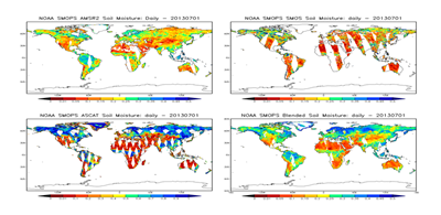
NOAA Soil Moisture Operational Product System (SMOPS) with GCOM-W1 AMSR2 soil moisture added.
© NOAA
The Global Change Observation Mission-Water (GCOM-W1) satellite, part of the Joint Polar Satellite Program (JPSS), has been in orbit since May 2012. Its Advanced Microwave Scanning Radiometer follow-on (AMSR2) instrument will provide a majority of global water cycle Environmental Data Records (EDR). One set of EDRs are the land-surface parameters (i.e., land surface soil moisture, and land surface type).
CICS-MD scientists are taking technical leadership of the Soil Moisture algorithm development and validation activities. The GCOM-W1 AMSR2 Algorithm System Package is designed to produce all AMSR2 EDR products at NOAA and is now operationally running for all lower level products. The soil moisture EDR algorithm is designed to be a higher level product and will be tested and made operational in this year.
The GCOM-W1 AMSR2 soil moisture product will play a significant role in the NOAA Soil Moisture Operational Product System (SMOPS), a blended product designed to produce “one-stop shopping” for all operational soil moisture products from different satellite sensors.