Blizzard of 2015 as Captured by Satellite
January 30, 2015 01:20 AM
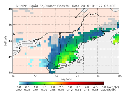
AMSU/MHS Snowfall Rate Product
© Jun Dong, NOAA
Huan Meng, NOAA/STAR, Patrick Meyers, ESSIC/CICS-MD, & Jun Dong, ESSIC/CICS-MD
The Blizzard OF 2015 that clobbered the New England this week was well captured by the ATMS and AMSU/MHS Snowfall Rate (SFR) product. The figure above is the SFR image from an ATMS overpass on January 27, 2015 at 06:40 Z. Currently, the product is being generated from five satellites including S-NPP, NOAA-18/-19 and Metop-A/-B. The combined satellites had 12 passes over the snowstorm on January 27. To see an animation of the SFR for the entire storm, click here.
« Back