Improving Surface Albedo Estimation with VIIRS data
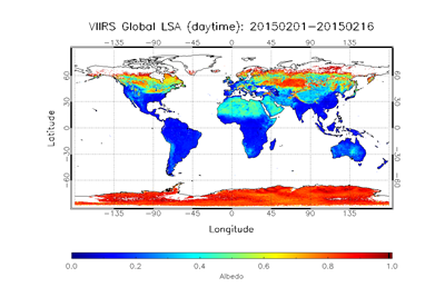
A global map of VIIRS land surface albedo composite from Feb 1-16, 2015
© NOAA
by Dongdong Wang, Shunlin Liang, and Yuan Zhou
Land surface albedo (LSA) is an important variable that governs shortwave radiation balance at the land surface by determining the amount of incident shortwave flux reflected back to the atmosphere. LSA characterizes the inherent properties of land surfaces with significant spatial and temporal variations, but is also affected by atmospheric conditions. Observations from the Visible Infrared Imaging Radiometer Suite (VIIRS) onboard the Suomi National Polar-orbiting Partnership (Suomi NPP) and future Joint Polar Satellite System (JPSS) missions provide us with a valuable data source to regularly monitor global LSA from space. Funded by NOAA, we improved the direct estimation algorithm to retrieve LSA from VIIRS by considering surface anisotropy, impacts of aerosol type, and land cover type. The refined algorithm addresses the issue of angular dependency and improves the temporal stability of LSA retrievals. Validation demonstrates the improved VIIRS LSA data have comparable or superior quality to existing LSA satellite products. In a recent study, we assessed the method and reliability of estimating daily mean albedo from satellite data. The study tackled the temporal-scaling issue in satellite LSA products. The use of local noon albedo in computing surface radiation budget (SRB) will result in a positive bias. The issue is especially prominent for snow-free vegetated surfaces, where the difference between local noon albedo and daily mean albedo can be as large as 10%. We developed two methods to estimate daily mean albedo, which can reduce the bias of estimating SRB by 3 W/m2.
« Back