Recent CICS-MD Research on Data Assimilation of Satellite-Observed Land Surface Information
November 5, 2018 08:23 AM

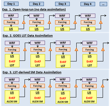
Three data assimilation experiments
© Li Fang
By Dr. Li Fang
Comprehensive land surface models are routinely used in the North American Land Data Assimilation System (NLDAS) and are widely employed to support weather prediction studies, water and energy cycle investigation and the research in land-surface processes on climate extremes. The reliabilities of these applications are greatly affected by the uncertainties in model parameters and forcing inputs. However, many of the surface parameters and model inputs implemented in the current NLDAS framework are static datasets generated from multi-year climatological averages (e.g. surface green vegetation fraction; GVF). Moreover, satellite-observed land surface products, like soil moisture (SM) and land surface temperature (LST), which are capable of providing spatially-continuous observations of surface parameters while accurately capturing the dynamics of surface conditions, have not been assimilated into current NLDAS system neither.
We conducted a series of studies to demonstrate the unique value of satellite-observed land surface information (GVF, SM, and LST) and the feasibility of assimilating them into land surface model (LSM) and weather forecast model to improve the simulation of land-atmosphere water and energy exchanges. With the tools of the NASA Land Information System (LIS) and the NASA-Unified Weather Research and Forecasting (NU-WRF) modeling system, we developed a semi-coupled LIS/WRF system to assimilate GVF, LST and SM in an offline Noah LSM and WRF model. The schematic above describes the three data assimilation experiments.
Improvements of both soil moisture simulations as well as forecasts of 2-meter air temperature and humidity and precipitation from NUWRF were obtained using the near real time GVF data products. The RMSE in SM estimates from off-line Noah model is reduced by around 1.0% (1.41%) during the green-up phase and by 1.48% (2.24%) over senescence phase for the surface (root-zone) SM simulations. As for validation on coupled WRF model, around 82.3% validation sites (out of 1178 sites) showed positive impact with the insertion of NRT GVF.
Two different types of LST assimilation techniques are implemented and the benefits from the techniques are compared. One of the techniques is to directly assimilate LST using ensemble Kalman filter (EnKF) data assimilation (DA) utilities. The other is to use the Atmosphere-Land Exchange Inversion model (ALEXI) as an “observation operator” that converts LST retrievals into the soil moisture (SM) proxy based on the ratio of actual to potential evapotranspiration (fPET), which is then assimilated into an LSM. It is found that WRF forecasts with the LST-based SM assimilation have better agreement with the ground weather observations than those with the direct LST assimilation or without the land TIR data assimilation.
For more information, see Dr. Fang's recent publications:
-
Fang, Li, Xiwei Zhan, Christopher Hain, Jifu Yin, and Jicheng Liu, 2018: Impact of GVF derivation methods on Noah Land Surface Model Simulations and WRF Model Forecasts. J. Hydrometeor. http://dx.doi.org/10.1175/JHM-D-18-0075.1, in press
-
Fang, Li, Xiwu Zhan, Christopher R. Hain, Jifu Yin, Jicheng Liu and Mitchell A. Schull, 2018: An assessment of the impact of land thermal infrared observation on regional weather forecasts using two different data assimilation approaches,Remote Sens., 2018, 10(4), 625; https://doi.org/10.3390/rs10040625
-
Fang, Li, Xiwu Zhan, Christopher R. Hain and Jicheng Liu, 2018: Impact of using near real-time green vegetation fraction in Noah Land Surface Model of NOAA NCEP on numerical weather predictions, Adv. Meteor., 2018, ID 9256396 (12 pgs.), https://doi.org/10.1155/2018/9256396
« Back