Water Quality Monitoring of Coastal Urban Waters Using In-Situ Chemical Measurements and Satellite Remote Sensing Data
Research Topic:
Climate Research, Data Assimilation, and Modeling
Task Leader:
Sujay Kaushal
CICS Scientist:
Sujay Kaushal
Sponsor:
NESDIS STAR SOCD
Published Date:
9/25/2017
2017 ANNUAL REPORT
Background
Large cities can be located in close proximity to coastal waters and therefore directly impact coastal carbon, nitrogen, and phosphorus. In addition to carbon and nutrient sources, urban areas export a large amount of labile organic carbon which can affect coastal water quality such as increased biochemical oxygen demand (BOD) (Kaushal et al. 2014). Thus, a fundamental question is how sources and transformations of carbon and nutrients change across the watershed-coastal interface and how does the "water quality footprint" of urbanization evolve across space and time in coastal waters. The ability to answer this question is critical for guiding and prioritizing river and coastal restoration efforts, which have already cost billions of US dollars.
Traditional in situ approaches for carbon and nutrient source tracking are very useful in understanding inputs and transformations of nutrients and organic carbon. However, they are very time consuming and there is generally limited temporal and spatial resolution. Satellite remote sensing is an invaluable tool for improving the understanding and management of coastal regions (DiGiacomo and McManus, 2006). Satellites provide frequent, synoptic observations for a number of key geophysical, biological and biogeochemical parameters (e.g., chlorophyll-a, sea-surface temperature, ocean surface vector winds). A number of recent efforts (e.g., DiGiacomo et al., 2004; Wang et al. 2009; Song et al. 2012) have specifically focused on use of satellite remote sensing data (satellite ocean color radiometry (OCR) observations) to improve understanding and monitoring of water quality in coastal and inland waters. In many cases, however, remote sensing data are used indirectly, i.e., as a proxy or indicator for contaminants contained in freshwater terrestrial runoff that cannot be measured remotely and it is highly necessary that both in-situ chemical measurements and satellite remote sensing data are used to monitoring coastal water quality changes with high temporal and spatial resolution.
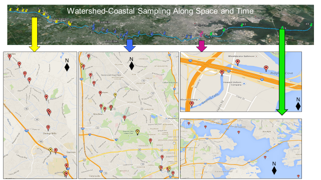
Figure 1: Example of longitudinal sampling across the land-coastal interface. We have worked on multiple sampling campaigns analyzing greenhouse gases, carbon, nutrients, base cations, dissolved inorganic carbon, and other parameters.
Accomplishments
We have collected in situ water quality samples along seasonal transects from the Gwynns Falls watershed to the Baltimore Harbor. These transects were chosen because Baltimore is one of the major cities in Chesapeake Bay watershed, which has experienced water quality problems receiving recent national attention. Furthermore, we can leverage data collected from the NSF supported Baltimore Long-Term Ecological Research (LTER) program (www.beslter.org).
Specifically, seasonal synoptic sampling campaigns were conducted along the Gwynns Falls and Baltimore Harbor, from the mouth of the Gwynns Falls (a NSF-funded Long-Term Ecological Research site) to the mainstem of the Chesapeake Bay. Coordinated sampling along land and coastal waters can provide a holistic view of how does the "water quality footprint" of urbanization propagate and dissipate across space and time in urban coastal waters.
Lab chemical analyses at UMD include chl-a, TSS, nutrients and carbon, carbon stable isotopes, greenhouse gases, 3D fluorescence of or dissolved organic matter (DOM). 3D fluorescence and isotopic composition will be used for tracking the source of nutrients and organic matter and the occurrence of transformation to greenhouse gases. Other in situ measurements include CTD and other water quality measurements: water temperature, salinity, chl-a fluorescence, light absorption and attenuation coefficients, turbidity, dissolved oxygen, and pH. In order to study the dynamics of various water quality parameters across the transects, our collaborators of NOAA will also utilize the tool of satellite radiometric remote sensing. Depending on what water quality products are developed with remote sensing proxies, we can characterize the continuum of coastal water quality conditions from upstream headwaters to downstream coastal zones. We expect that such a study can provide us insights into the evolution of nutrients and carbon on the coastal end of the watershed-coastal interface.
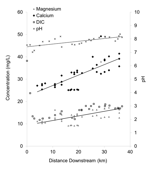
Figure 2: Example of observed longitudinal trends in base cations and dissolved inorganic carbon (alkalinity) that can influence buffering of coastal ocean acidification from urban watersheds. We recently completed a sampling campaign where we can analyze these types of data related to coastal ocean acidification further and will present at an upcoming CLIVAR meeting.
Field work and chemical analyses have been conducted by a technician of the Biogeochemistry Lab at the University of Maryland, Shahan Haq. Shahan is now enrolled as a graduate student in the Department of Geology at UMD under the supervision of Dr. Sujay Kaushal. Dr. Kaushal will continue help to advise and monitor the research associated with water quality data analysis and publications.
Planned work
This is a continuing project over multiple years. We will continue analyses of carbon, nutrients, and greenhouse gases, and work on papers from the project. Our results will also be presented at an upcoming CLIVAR meeting as an invited keynote talk.