Incorporation of Near-Real-Time Suomi NPP Land Surface Temperature Data into the NCEP Land Modeling Suite
Research Topic:
Climate Research, Data Assimilation, and Modeling
Task Leader:
Zhen Song
CICS Scientist:
Zhen Song
Sponsor:
NESDIS STAR SMCD
Published Date:
9/25/2017
2017 ANNUAL REPORT
Background
This report summarizes the ongoing project “Incorporation of Near-Real-Time Suomi NPP Land Surface Temperature (LST) Data into the NCEP Land Modeling Suite”.
The VIIRS LST environmental data record (EDR) generated by the JPSS Interface Data Processing Segment (IDPS) provides effective land surface skin temperature value at the time of overpass with spatial resolution of 750m at nadir, which is a unique data source of obtaining LST information at regional and global scales. However, due to the complexity of land-atmosphere interactions as well as unavailability of high quality, real-time products, satellite-derived land surface temperature is not well incorporated in improving numerical weather forecast.
The goal of this project is to accelerate the use of VIIRS LST in a suite of operational numerical prediction models at NOAA’s National Centers for Environmental Prediction, including NCEP NAM, NCEP GFS and NLDAS, with two steps: (1) Produce Global Gridded VIIRS LST data at 0.036°and hourly resolution for NCEP NAM, GFS, and NLDAS;(2) Apply gridded VIIRS LST data to evaluate the model performance of NAM, GFS, and NLDAS.
Accomplishments
During this funding cycle we mainly made following accomplishments: produce the gridded VIIRS LST in routine mode at STAR server; develop the diurnal temperature model based on GOES LST datasets and apply the models to VIIRS hourly LST interpolation; produce the hourly interpolated LST data for EMC people. In detail, the accomplishments include:
1) Produce the gridded VIIRS LST in routine mode at STAR server
2) Develop the diurnal temperature model based on GOES LST datasets for CONUS region
Build monthly diurnal temperature model (DTM) by geostationary LST (GOES):
- Collect monthly diurnal LST from GOES in different groups divided by longitude, latitude, land cover and elevation for CONUS
- Build the diurnal temperature model according to Gottsche and Olesen semi-physical model by non-linear least square fit
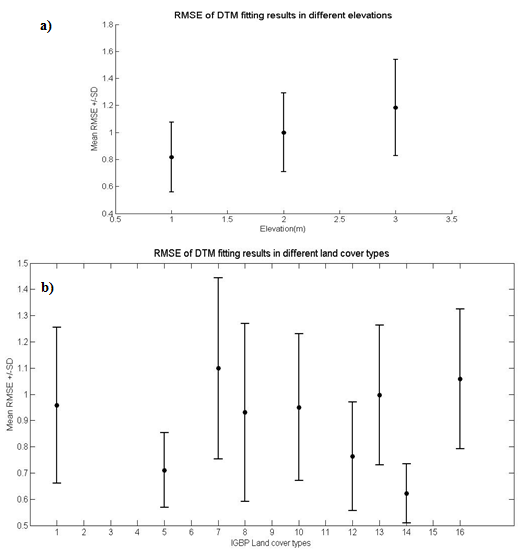
Figure 1. Diurnal temperature model fitting accuracy in (a) different elevations and (b) different land cover types
3) Apply the diurnal temperature model to produce VIIRS hourly interpolated LST
Based on the diurnal temperature model, instantaneous VIIRS LST is interpolated to the nearest hourly LST. First, the observed daytime and nighttime VIIRS LST are involved to correct the monthly DTM for a specific day; second, the hourly interpolated LST is calculated based on the corrected DTM. The hourly interpolated LST has been validated by SURFRAD ground measurements and the overall accuracy is suitable for model evaluation.
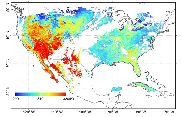
Figure 2. VIIRS Interpolated LST for 19Z and 20Z, June, 25, 2016
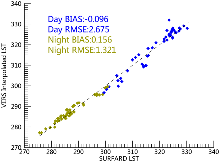
Figure 3. VIIRS interpolated LST validation by SURFRAD ground measurements for Aug.2015
4) Produce the hourly interpolated LST data for EMC people for model LST evaluation
Planned work
-
Develop the software package for VIIRS hourly LST producing.
-
Evaluate the model LST by gridded hourly VIIRS LST.
Products
· VIIRS Hourly LST