Development and Improvement of Satellite Data Applications for Global and Regional Weather Monitoring and Forecasting
Research Topic:
Climate Research, Data Assimilation, and Modeling
Task Leader:
Xiaolei Zou
CICS Scientist:
Xiaolei Zou
Sponsor:
NESDIS STAR
Published Date:
9/25/2017
2017 ANNUAL REPORT
Background
AMSU-A and MHS are currently on board NOAA-18, -19 and two European Meterological Satellites (e.g., MetOp-A and –B). NOAA-19, MetOp-A, -B, were launched on 6 February 2009, 19 October 2006, and 17 September 2012, respectively.MetOp-A and –B satellites are configured in the mid-morning orbits with the local equator crossing times (LECT) around 0930 local time (LT), whereas NOAA-18 and -19 are the afternoon orbits with the LECT around 1400 LT. With these constellations, AMSU-A and MHS measurements are provided at least four times a day at any location of the globe for profiling the atmospheric temperature and humidity.The 20 microwave channels from AMSU-A and MHS had played and will continue to playa key role for numerical weather prediction (NWP) through radiance assimilation. Since MHS is more sensitive to both water vapor and clouds than AMSU-A, it is more challenging to use the MHS data in NWP systems due to the highest uncertainty in the forward operators and cloud forecasts (Karbou et al., 2010;Bouchard et al., 2010; Bormann et al., 2010). Recently, it was shown that impacts of MHS data assimilation on short-term quantitative precipitation forecasts (QPFs) could be significantly improved by modifying the quality control (QC) schemes (Qin et al., 2013; Zou et al., 2013; Qin et al., 2016). The current approach of using MHS-only data for cloud quality control could misclassify the cloud-affected radiances as clear. Unlike the ATMS data implemented in Gridpoint Statistical Interpolation (GSI) system (Zou et al., 2013), AMSU-A and MHS radiance data are digested in the NCEP NWP data assimilation systemsin two separate Binary Universal Form for the Representation of meteorological data (BUFR) files. Thus, the QC scheme for MHS only data assimilation must be done with its own radiances without information on the lower frequency measurements from AMSU-A.
Accomplishments
Since the launch of NOAA-15 satellite in 1998, the observations from microwave temperature and humidity sounders have been routinely disseminated to user communities through two separate data streams. In the Advanced Microwave Sounding Unit-A (AMSU-A) data stream, brightness temperatures at 15 channels are available primarily for profiling atmospheric temperature from the earth surface to low stratosphere. In the Advanced Microwave Sounding Unit-B (AMSU-B) or Microwave Humidly Sounder (MHS) data stream, the brightness temperatures at five channels are included for sounding water vapor in the low troposphere. Assimilation of microwave radiance data in numerical weather prediction systems has also been carried out with AMSU-A and AMSU-B (MHS) data in two separate data streams. A new approach is to combine AMSU-A and MHS radiances into one data stream for their assimilation. The National Centers for Environmental Prediction Gridpoint Statistical Interpolation analysis system and the Advanced Research Weather Research and Forecast model are employed for testing the impacts of the combined datasets. It is shown that the spatial collocation between MHS and AMSU-A field of views in the one data stream experiment allows for an improved quality control of MHS data, especially over the conditions where the liquid-phase clouds are dominate. As a result, a closer fit of analyses to AMSU-A and MHS observations is obtained, especially for AMSU-A surface-sensitive channels. The quantitative precipitation forecast skill is improved over a 10-day period when Hurricane Isaac made landfall.Figure 1 provides the ETSs of the model-predicted 3-h accumulative rainfall amounts at 1-mm, 5-mm, 10-mm and 15-mm thresholds from 0600 UTC to 1500 UTC 30 August 2012. The skill of QPFs associated with the landfall Hurricane Isaac is significantly improved by combining AMSU-A and MHS data from the same polar-orbiting satellite into the same BUFR file for the GSI analysis system.
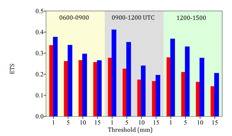
Figure 1. ETS scores of 3-h accumulative precipitation during 0600-0900, 0900-1200, 1200-1500 for the previous two data streams (red bars) and the new one data stream (blue bars) experiments initialized at 0000 UTC 30 August 2012.
The launch of the Japanese Advanced Himawari Imager (AHI) on October 7, 2014 represents a new era of geostationary operational environmental satellite (GOES) imagers, providing many more channels than any previously launched GOES imagers for the first time. A convective initiation algorithm was developed and tested over China using AHI data.
Planned work
-
Use Advanced Himawari Imager (AHI) data for detecting the convective initiation (CI)
-
Complete a journal paper on AHI CI over Taiwan and China
Publications
Zou, X., Z. Qin and F. Weng, 2016: Impacts from assimilation of one data stream of AMSU-A and MHS radiances on quantitative precipitation forecasts. Quart. J. Roy. Meteor. Soc., doi:10.1002/qj.2960.
Presentations
The 97th Annual Meeting of America Meteorology Society, 22-26 January 2017, Seattle, Washington. A poster presentation entitled “Impacts from Assimilation of One Data Stream of AMSU-A and MHS Radiances on Quantitative Precipitation Forecasts” by Qin, Zou and Weng at the 21st Conference on Integrated Observing and Assimilation Systems for the Atmosphere, Oceans, and Land Surface.