GOES-R Water Cycle Products & Services to Support the National Weather Service
Research Topic:
Land and Hydrology
Task Leader:
E. Hugo Berbery
CICS Scientist:
Patrick Meyers
Sponsor:
NESDIS STAR CoRP SCSB
Published Date:
9/26/2017
2017 ANNUAL REPORT
Background
The Cooperative Institute for Climate and Satellites at the University of Maryland (CICS-MD), in conjunction with its NOAA/NESDIS/Center for Satellite Applications and Research (STAR)/Cooperative Research Programs (CoRP)/Satellite Climate Studies Branch (SCSB) partner, will support the Geostationary Operational Environmental Satellite - R Series (GOES-R) Risk Reduction Program (GOES-R3) through this proposal focused on research and development (R&D) of water cycle products that will serve multiple users at NOAA’s National Weather Service (NWS). The primary topical areas include: precipitation, land surface hydrology, water quality and high impact weather. The R&D will exploit the new capabilities from baseline and future products of the GOES-R satellite, mainly measurements (or proxies of them) from the Advanced Baseline Imager (ABI) and the Geostationary Lightning Mapper (GLM). In particular, measurements from the Himawari-8, rapid scan operations of current GOES satellites and ground lightning networks will be exploited to advance water cycle products.
The targeted end users within NWS include the National Water Center (NWC), the Weather, Ocean and Tropical Prediction Centers (WPC, OPC and TPC) and the NWS Pacific Regions, where collaborations are already underway. Additionally, synergy and exploitation of Joint Polar Satellite System (JPSS) products will also be included in this project, in particular, direct broadcast (DB) data which will greatly reduce data latency and offer a greater potential of fusion with GOES-R data. The advantage of reduced latency from DB data has been demonstrated by the NESDIS Snowfall Rate product that was evaluated at NWS Weather Forecast Offices (WFOs) over the past few years. Finally, the SCSB/CICS-MD Satellite Proving Ground will be used to test the new products in a near-real time capability and form the basis for testbed activities with the NWS users.
Accomplishments
This new start project in FY16 (July 1) had just a few milestones that were started during the initial 6-month reporting period; these as well as the overall project milestones are noted in the table below. Some specific details on the project include:
1. Workshop with NWS and NOS stakeholders to define project priorities:
In order to determine project priorities as we move ahead in this multi-year project, we met with members of the NWS/Office of Water Prediction (OWP) on October 19, 2016, to describe to them the current project (as proposed) and potential new topics (as outlined in the proposal) to get their input as to their priorities. Brian Cosgrove represented the interests of NWS/OWP and was joined by Dave Kitzmiller and Yu Zhang from OWP; Cosgrove gave a nice overview of the current/future needs of satellite products at OWP. Topics presented by the project team included:
-
Review of ongoing activities in support of NWS and of potential interest to NWS– Scott Rudlosky and Patrick Meyers
-
Improved precipitation rates for the NWS Pacific Region– Nai-Yu Wang
-
Advancement of LEO snowfall rate retrievals– Huan Meng
-
Water quality– Christopher Brown
-
Global flood estimate and forecasting using satellite precipitation and hydrological models– Bob Adler and Huan Wu
-
High resolution remote sensing of evapotranspiration (ET) and soil moisture– Chris Hain
-
Global snow depth and water equivalent estimations using satellite and in-situ data– Cezar Kongoli
The first two topics are tasks in progress; of the other activities presented, OWP had the most interest in the snowfall rate and the ET/soil moisture projects. Next of interest was the water quality and global flood activities. Because of the budget constraints in year 2 of the project, our plan will be to complete the first two tasks and work next on the snowfall rates. Water quality is a focus of the OWP starting in FY19, so that work will strongly be considered in year 3 of the project. (It should be noted that Chris Hain has departed CICS-MD so it would be unclear how that activity would be carried out).
2. OCONUS Rain Algorithm for NWS Pacific Region
This task is being carried out by CICS-MD research scientists Nai-Yu Wang and Yalei You. OCONUS rain algorithm for the Pacific region is under development. The preliminary algorithm development makes use of IR channels from Himawari-8 on board of the Japanese Meteorological Agency (JMA) and lightning observations (flash occurrence) from ground lightning network GLD360. Figure 1 top panel shows the brightness temperatures (TBs) from IR window channel 13 from Himawari-8 satellite.
The colder IR TBs signal higher cloud top height which implies higher vertical extent of the clouds and possible heavy rainfall. However, the correlations between IR TBs and surface rainfall are very weak. Methods of deriving surface rainfall using IR TBs through techniques of relating IR TBs and surface rainfall rate through linear or more complex regression methods have not yielded good results. A different methodology is used here and the initial assessment shows great promises. The bottom panel in Figure 1 shows the identification of convective clouds (in red) and other precipitating clouds (in blue) through a local minimum temperature and temperature gradient technique (on the left), and convective cloud identification from combined IR TBs and lightning flashes.
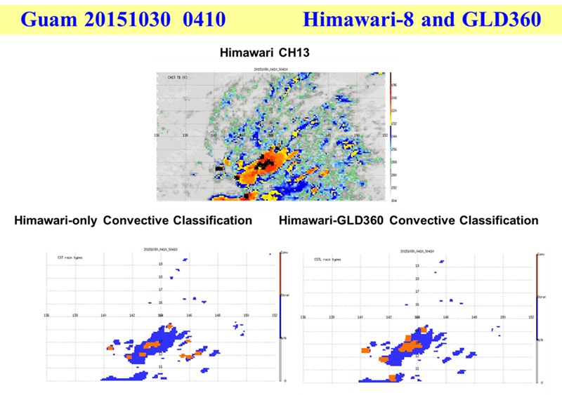
Figure 1. Himawari-8 Channel 13 IR imagery for 30 October 2015, 0410 UTC (top). The bottom panel shows the convective (red) and non-convective (blue) identified by the satellite QPE algorithm using IR only (on the left) and IR and lightning combination (on the right).
The rain storm pattern and amount between Quam radar and IR-lightning technique are highly comparable. Further algorithm refinements on the lightning information for oceanic convective rigor and rainfall rate relationships, and the evolution of convective cells using frequent GEO-IR observations will be the focus for next year. Coincident Guam and Hawaii islands ground radars, space-borne radar and radiometer from GPM, and Himawari-8 are being collected for algorithm development and validation. Algorithm validation effort will be a focus for this project as well.
3. ProbSevere for Ocean Regions
Two CICS-MD researchers and two UMD undergraduate students are contributing to this effort. This research is the senior theses research for the two undergraduate students. The senior thesis research is laying the ground work for more detailed analyses during summer 2017.
a) Complete development and testing of lightning advection rain rate algorithm over CONUS that also exploits LEO DB (Ground)
The shape and intensity of the precipitation field changes dramatically between consecutive LEO observations, requiring a transformation procedure to produce a realistic time-evolution of a storm system. Morphing of LEO precipitation features was tested using a basic optical flow technique. The method has only been applied to two consecutive LEO swaths, and not a full composite of all constellation members. Further testing and evaluation of the lightning-derived motion is required. Degrading the GLD360 lightning observations to the GLM 8 km horizontal resolution appears to reduce the precision of the advection technique. A downscaling technique may be needed to more accurately depict the storm motion field.
b) Develop ProbSevere training database over ocean; perform testing at OPC and NWS Pacific Region (Algorithm)
Doug Kahn is building a training database of offshore thunderstorms in the Atlantic Ocean and Gulf of Mexico. The selection of cases was aided by examination of turbulence reports from commercial aircraft. The turbulence reports were queried to identify those that could be attributed to nearby thunderstorms. Automated Warning Decision Support System – Integrated Information (WDSS-II) procedures have been developed to data mine the satellite and lightning datasets. User-defined information is extracted from storm clusters using WDSS-II. As shown in Figure 2, the storm clusters are then visualized in ArcMap (GIS) to view the progression of storms throughout entire days.
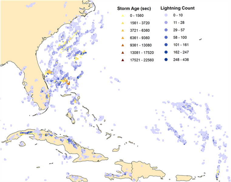
Figure 2. Depiction of the storm age and lightning count for all storms occurring on October 1, 2015. The storm age is for the larger storm features and the lightning count is for the smaller storm core features. Red shades indicate longer lived storms and the darker blues indicate larger lightning counts.
Smaller features are classified as Cores (Min. Size: 1280 km²), and Storms refer to larger convective regions (Min. Size: 6400 km²). Twelve of the planned twenty five cases have been processed, with each case expected to contain dozens of Storms and hundreds of Cores. With the automated procedures in place, the remaining case should be processed quickly before moving into the database analysis phase.
Planned work
The plans for the next six months include:
-
Rescope the project based on FY17 funding levels and the input received from NWS/OWP.
-
Continue to work on and test OCONUS rain algorithm by generalizing the relation between rainfall and IR temperatures plus lightning. Because of the sparsity of oceanic lightning, the utility of lightning in identifying deep convective cells and lightning-rainfall relationships need to be refined from the continental relationships previously developed. Additional development will be the examination of using high temporal information of the GEO-IR temperature variations to evaluate the evolution of the convective storm (is the storm growing or decaying).
-
Develop more advanced techniques will for the morphing of LEO precipitation features. Further testing and evaluation of the lightning-derived motion is required, and we plan to explore downscaling techniques in an attempt to more accurately depict the storm motion field. Results from the OCONUS Rain and Storm Tracking aspects of this project will provide important insights into the morphing of LEO precipitation features, and future efforts will work to incorporate this complementary information.
-
We will continue to process case studies that sample a variety of storm types in different seasons and regions to build the off-shore ProbSevere storm archive (training dataset). GIS software will be used to identify storms of interest on selected case study days. An important next step is to incorporate Global Forecast System (GFS) model data to augment the lightning and satellite information. The accuracy of the storm tracking and trending procedures will be characterized to provide recommendations for potential improvements in future versions. Statistics will be computed for all storms to document findings and aid in the development of an off-shore thunderstorm intensity tool.
Presentations
Nai-Yu Wang, “"Combining IR and Lightning For Enganced GOES-R Rain Estimates in the Pacific Region". 2016 GOES-R/JPSS OCONUS Satellite Proving Ground Technical Interchange Meeting, Honolulu, HI, June 30, 2016.
Nai-Yu Wang and Yalei You – “Combining IR and Lightning for Enhanced Geostationary Satellite Rain Estimates”. Eighth workshop of the International Precipitation Working Group (IPWG-8); Bologna, Italy, October 3-7, 2016
Daniel Vitelli, D., and P. C. Meyers, 2017: Gale-forced storm prediction over the oceans.16th Annual AMS Student Conference, Amer. Meteor. Soc., Seattle, WA, January 22, Poster S42.
Kahn, D. T., S. D. Rudlosky, P. C. Meyers, and M. J. Pavolonis, 2017: Evaluating the ProbSevere Model Over the Atlantic Ocean Using WDSS-II,7th Conference on Transition of Research to Operations, Amer. Meteor. Soc., Seattle, WA, January 23-26, Poster 880.
Other
Interaction with operational partners–
-
Met with the NWS/Office of Water Prediction to review project objectives and determine priorities
-
A presentation at the AMS annual meeting included coauthors from the National Hurricane Center (NHC), Aviation Weather Center (AWC), Weather Prediction Center (WPC), and the Ocean Prediction Center (OPC).
-
Side meetings were held at the 2017 AMS Annual Meeting between Scott Rudlosky and individuals from both the National Weather Service (NWS) and Federal Aviation Administration (FAA). Visits to several national centers and two WFOs have helped to guide our efforts.
-
Nai-Yu Wang visited the National Weather Service Pacific Region Headquarters in Honolulu from June 20 to July 1, 2016 to demonstrate a new satellite QPE capability of combining infrared and lightning observations from the upcoming GOES-R using the current geostationary satellite Himawari-8 and ground lightning network GLD360 data.