Satellite Tools for Superstorm Sandy
July 20, 2015 09:12 AM
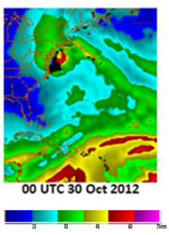
Blended Total Precipitable Water (bTPW)
© NOAA
A recently published paper by lead author Michael Folmer demonstrates how current satellite products assisted NOAA forecasters during Superstorm Sandy and introduces some new satellite products that could be used to analyze and predict future high impact weather systems. Satellites played an integral role in the analysis and forecast of Hurricane Sandy‘s track and intensity. The NOAA National Hurricane Center, Ocean Prediction Center, and Weather Prediction Center all relied on information from satellites to make critical warning decisions using various satellite products that assist with diagnosing tropical cyclone intensity, surface winds over the ocean, and heavy precipitation. As part of the Geostationary Operational Environmental Satellite – R-series (GOES-R) and Joint Polar Satellite System (JPSS) Proving Ground activities, new satellite products were available in experimental form to assist with observing this unique, high impact event.
For monitoring and real-time analysis, forecaster used:
-
Visible and infrared satellite imagery (for Dvorak technique);
-
AMSU products;
-
Satellite scatterometers; and
-
Multi-satellite-platform Tropical Cyclone Surface Wind Analysis (MTCSWA).
The NWP models assimilated satellite data to predict the hurricane track and intensity changes, especially ocean heat content estimates from satellite altimetry. An experimental product included lightning data.
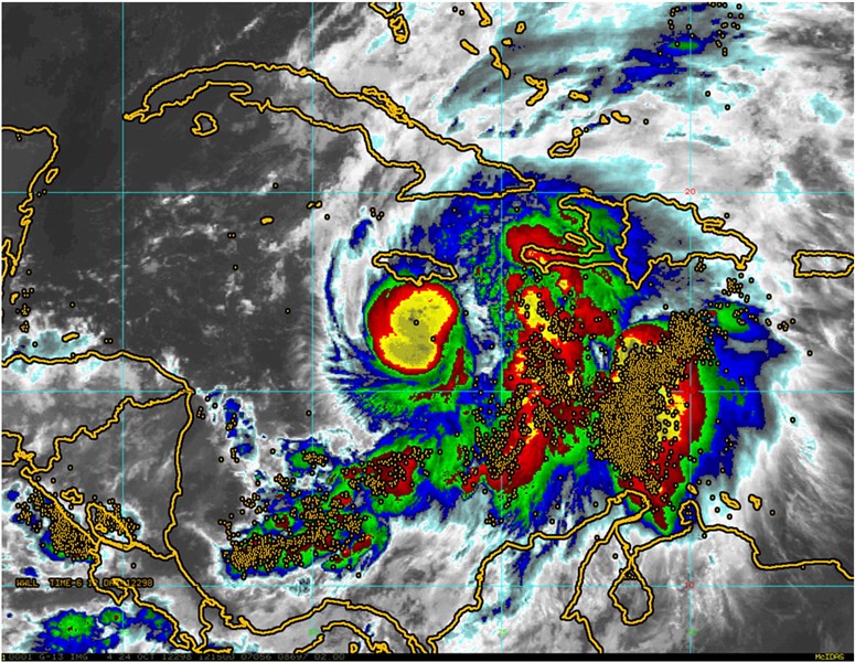
The graphic above, from the article, shows lightning locations (gold points) within 6 hours of 12 UTC on 24 Oct 2012 on a color enhanced GOES IR image.
Satellite precipitation and moisture fields helped to fill in gaps over the ocean. The products used included:
-
Blended Total Precipitable Water (bTPW);
-
Hydroestimator (H-E);
-
Ensemble Tropical Rainfall Potential (eTRaP); and
-
Microwave snowfall rates from AMSU.
Emerging GOES-R products that could be used for forecasting future hurricanes include:
-
Advanced Baseline Imager;
-
Multi-Channel Imagery;
-
Super Rapid Scan Operations;
-
Atmospheric Motion Vectors; and
-
Geostationary Lightning Mapper.
For JPSS, the recommended products are from the:
-
Visible Infrared Imagery Radiometer Suite (VIIRS);
-
Ozone Mapping and Profiler Suite (OMPS); and
-
Advanced Technology Microwave Sounder (ATMS).
For more details, see the article: http://authors.elsevier.com/a/1RNj9cd3RqZVD
Folmer, Michael J., Mark DeMaria, Ralph Ferraro, John Beven, Michael Brennan, Jaime Daniels, Robert Kuligowski, Huan Meng, Scott Rudlosky, Limin Zhao, John Knaff, Sheldon Kusselson, Steven D. Miller, Timothy J. Schmit, Chris Velden, and Brad Zavodsky, 2015: Use of satellite tools to monitor and predict Superstorm Sandy 2012: Current and emerging products, Atmos. Res., 166, 165-181, http://dx.doi.org/10.1016/j.atmosres.2015.06.005.
« Back