The Mid-Atlantic Deluge from the GCOM-W Satellite
July 31, 2018 09:29 AM
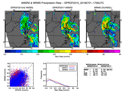
Comparisons of AMSR2 Current and Improved Precipitation Algorithm
© Patrick Meyers
Parts of Maryland and the Mid-Atlantic experienced record-breaking rain in the past week (July 21-25), causing wide-spread flooding and tree damage. The persistent precipitation was supported by a constant supply of moist tropical air.
This area was observed twice-daily by the Advanced Microwave Scanning Radiometer 2 (AMSR2) on the Global Change Observation Mission--Water (GCOM-W) satellite. CICS-MD Scientist Patrick Meyers (supporting STAR/CoRP) compared both the rainfall estimates from the current operational AMSR2 precipitation algorithm (GPROF2010V2) and its potential replacement (GPROF2017) to radar rain rate estimates.
As shown in the maps, GPROF2017 consistently detects rain/no-rain better than GPROF2010V2, and improves rain rate estimates for tropical air masses over land. In the coming months, GPROF2017 will be tested using ancillary NOAA data and considered as a replacement for the operational AMSR2 precipitation product.
« Back