CICS Researchers Develop Tools for Monitoring Drought from Space
May 23, 2013 05:05 AM
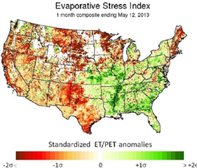
Evaporative Stress Index
©
Researchers at the Cooperative Institute for Climate and Satellites led by Christopher Hain, along with colleagues from NOAA and the USDA Agricultural Research Service have developed a unique satellite based methodology for mapping drought over the United States. The tool is currently being evaluated for use as a part of the decision making process at the National Drought Mitigation Center in preparation of the weekly United States Drought Monitor and at the NOAA Climate Prediction Center in support of their monthly drought briefing.
Background:
The Evaporative Stress Index (ESI) provides objective, high-resolution information related to evaporation of water from land surface. The method to compute ESI merges satellite data with other meteorological observations to determine Anomalies in how much water is used by crops and vegetation, which is especially important during conditions of drought. Signatures of vegetation stress can be detected by determining how fast the land surface heats up before any deterioration in vegetation occurs, in contrast to others methods which only look at how “green” vegetation is to determine its health. ESI can also provide an effective early warning signal of impending “flash droughts”, which can be brought on by extended periods of hot, dry and windy conditions leading to a rapid loss of soil moisture. This has been demonstrated by the ability of ESI to capture the 2012 “flash drought” over the central United States, where ESI showed developing drought conditions before it was shown in other drought indicators. Finally, methods are being developed to merge valuable ESI information with computer models which attempt to forecast future drought and weather conditions.
Significance:
ESI provides additional assessment of current drought conditions, supplementing precipitation and modeling-based indices and provides an invaluable resource to decision-makers who usually depend on a convergence of information in the decision making process. This work supports NOAA’s goal of climate adaptation and mitigation, improved freshwater resource management and reducing loss of life, property, and disruption from high-impact events. ESI maps are distributed during the growing season through the Drought Portal (www.drought.gov) maintained by the National Integrated Drought Information Service.
ESI Website: http://hrsl.arsusda.gov/drought/
NIDIS Link: http://www.drought.gov/drought/content/products-current-drought-and-monitoring-remote-sensing/evaporative-stress-index
Contact Information: Christopher Hain, Cooperative Institute for Climate and Satellites (CICS)
« Back