Data Assimilation of CryoSat-2 Sea Ice Thickness
Satellite and Aircraft Sea Ice Thickness
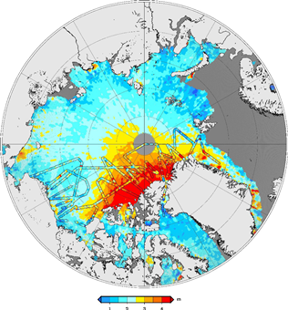
© Allard et al., 2018.
CICS-MD Scientist Sinéad Farrell has a new article, published in the 15 September 2018 issue of Advances in Space Research, on improving the results of coupled ice-ocean models. In this study, ice thickness products from CryoSat-2 were used to initialize the model for an 18-month run. Model runs with and without the CryoSat-2 initialization were then compared with data collected at or near the ground (moored upward looking sonar, drifting ice mass balance buoys, and NASA Operation IceBridge ice thickness). The figure shows the Arctic with satellite data (background) and the IceBridge aircraft data (parallel lines) with the same color scale. The satellite data improved the model’s performance for the first six months of the simulation, in terms of bias and root mean square error (RMSE). The largest improvements were over multi-year ice. These results suggest that satellite sea ice thickness measurements should be assimilated in coupled ocean-ice models. Sea ice simulations must be improved for NOAA to understand and explain changes in the global climate. Allard, R. A., S. L. Farrell, D. A. Hebert, W. F. Johnston, L. Li, N. T. Kurtz, M. W. Phelps, P. G. Posey, R. Tilling, A. J. Wallcraft, 2018: Utilizing CryoSat-2 Ice Thickness to Initialize a Coupled Ice-Ocean Modeling System, Adv. Space Res., 62 (6), 1265–1280, https://doi.org/10.1016/j.asr.2017.12.030.
« Back