Folmer's Dropsondes in the Saharan Air Layer
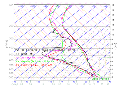
Skew-T Results of Dropsondes vs. Satellite Profiles
© NOAA HRD
CICS-MD Scientist Michael Folmer has been collaborating with the NOAA Hurricane Research Division and Aircraft Operations Center. He designed a research mission to deploy dropsondes in an effort to sample the Saharan Air Layer, which was carried out on September 20. Forty JPSS sondes were dropped on this mission. A total of 30 sondes were co-located with NOAA-20 observations. The data on Total Precipitable Water (TPW) from 19 of the dropsondes were compared with co-located satellite data from the NOAA Unique CrIS/ATMS Processing System (NUCAPS) Skew-T product. In the figure below, Skew-T plots compare the ATMS (MW, green) and ATMS + CrIS (MW+IR, red) retrievals to the interpolated Global Forecast System (GFS,pink) and, if available, to the G-IV dropsondes (Sonde, gray thin line) and smoothed Sonde (black line). The analysis has not yet been completed but the results are suggestive. For the comparison shown above, the combination of the microwave ATMS and infrared CrIS is closer to the dropsonde results than the ATMS alone. The Saharan Air Layer (the leftward bulge in the Skew-T) is important because this dry dusty air inhibits the formation and growth of tropical storms and hurricanes. Folmer has another 35 dropsondes for a future flight. This project serves to validation/calibration of satellite instruments along with furthering climate analysis of the Saharan Air Layer.
« Back