Improving Satellite-Generated Land Surface Phenology
March 31, 2014 08:47 AM
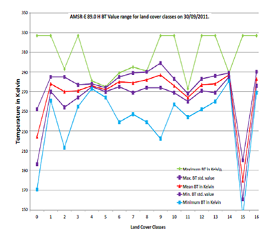
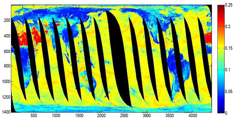
CICS Scientists Mukesh Singh Boori and Ralph Ferraro just published a new article on microwave polarization and gradient ratio (MPGR) in the Journal of Geology & Geosciences. Satellite-generated brightness temperatures (BT) are largely influenced by soil moisture and vegetation cover. Microwave polarization and gradient ratio (MPGR) is an effective indicator for characterizing the land surface phenology from sensors like EOS Advanced Microwave Scanning Radiometer (AMSR-E).The MPGR combines the microwave gradient ratio with polarization ratio to determine surface characteristics (i.e., bare soil/developed, ice, and water) and under cloud covered conditions when this information cannot be obtained using optical remote sensing data. Their study investigated the use of the HDF Explorer, Matlab, and ArcGIS software to process the pixel latitude, longitude, and BT information from the AMSR-E imagery. They used the polarization and gradient ratio from AMSR-E BT for 6.9, 10.7, 18.7, 23.8, 36.5, and 89.0GHz to identify seventeen land cover types. A smaller MPGR indicates dense vegetation, with the MPGR increasing progressively for mixed vegetation, degraded vegetation, bare soil/developed, and ice and water. This information can help improve the characterization of land surface phenology for use in weather forecasting applications, even during cloudy and precipitation conditions which often interferes with other sensors. The figure shows the MPGR value range for polarization ratio (PR 36.5).
Boori, M. & R. Ferraro, 2014, Microwave polarization and gradient ratio (MPGR) for global land surface phenology. J. Geol. Geosci., 2,1–10, http://dx.doi.org/10.4172/2329-6755.1000114.
« Back