MiRS Land Surface Temperature
August 7, 2017 07:17 AM
by Chris Grassotti, CICS-MD and Carlos Perez-Diaz, CUNY-CREST
The Microwave Integrated Retrieval System (MiRS) is the NOAA official microwave-only operational satellite retrieval algorithm, and has been running at NOAA since 2008. Currently, passive microwave data from a total of 8 different satellites are processed operationally (https://www.star.nesdis.noaa.gov/mirs). The algorithm is based on a 1-dimensional variational approach in which all relevant elements of the atmospheric and surface state are retrieved simultaneously. The official retrieval products from MiRS include temperature and water vapor profiles, surface temperature and emissivity, liquid and frozen hydrometeors, precipitation rate, as well as cryospheric products such as sea ice concentration and snow water equivalent. CICS-MD scientists are playing a key role in management, development, monitoring, and improvement of the MiRS algorithm. A critical component of this activity is the validation of the various retrieval products from MiRS by comparing with diverse reference data sets.
One potential advantage of satellite microwave-based retrievals is the ability to measure land surface temperature (LST) with near global coverage over long time periods with a consistent methodology, in both clear and cloudy (non-raining) conditions. Assessment of MiRS LST from Soumi-NPP/ATMS measurements is being conducted with comparison to multiple reference data sets. One of the reference sets is the SURFRAD ground-based network over the US, which includes measurement of upwelling and downwelling longwave fluxes, from which LST can be derived. The figure below shows an example of comparisons over a 13 month period (May 2016 – May 2017) for six SURFRAD locations (Nevada, Illinois, Montana, Mississippi, Pennsylvania and South Dakota). Only data which were precipitation-free as determined from MiRS are included.
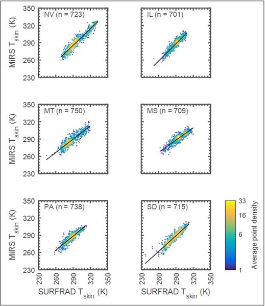
The results show that performance is consistent between stations, which are located in widely different climatic zones, and with quite different surface characteristics. Overall, the bias, standard deviation, and correlation are -1.8 K, 5.3 K, and 0.92, respectively. Given that comparison between satellite microwave measurements and surface-based infrared measurements of LST are expected to have some disagreement due to differences in spatial and spectral sampling characteristics, this level of agreement is quite encouraging.
« Back