Monitoring the 3D Structure of Forests
February 25, 2021 05:01 PM

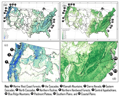
Figure: Conterminous US maps of (a) canopy height (CH) and (b) canopy fraction cover (CFC) for 2019. Close-ups show (c) CH variations in ecoregions of the Northwestern Forested Mountains, and (d) CFC variations in the Appalachians and Piedmont Plateau.
© NOAA/NESDIS
CISESS Scientists Khaldoun Rishmawi and Chengquan Huang (Department of Geographical Sciences, University of Maryland) and Xiwu Zhan from NOAA-NESDIS Center for Satellite Applications and Research (STAR) published an article last month in the Journal Remote Sensing. The article demonstrated the potential of integrating measurements from the Global Ecosystem Dynamics Investigation (GEDI) Light Detection and Ranging (LiDAR) sensor with spatially contiguous observations from the Visible Infrared Imaging Radiometer Suite (VIIRS) to produce 1-km resolution wall-to-wall maps of canopy height, plant area index, and canopy fraction cover, which will benefit greatly to our efforts for improving the JPSS VIIRS Annual Surface Type product. The methodology developed through this study may allow multi-decadal monitoring of changes in key forest structural attributes using consistent satellite observations acquired by orbiting and forthcoming VIIRS instruments. A multi-decadal record of Earth’s forests 3D structure is essential for improving our understanding of the true magnitude of global forest biomass stocks, for modeling biomass change associated with forest disturbance and regrowth, and for prognosticating future net forest carbon fluxes.
Rishmawi, K.; Huang, C.; Zhan, X. Monitoring key forest structure attributes across the conterminous United States by integrating GEDI LiDAR measurements and VIIRS data. Remote Sens. 2021, 13, 442. https://doi.org/10.3390/rs13030442.
« Back