Moore, Oklahoma F-5 Tornado Viewed by Satellite
July 5, 2013 10:23 AM
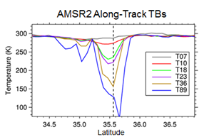
Vertically polarized brightness temperatures show strong scattering of microwave emissions by large ice particles in the atmosphere.
© Patrick Meyers
The Global Change Observation (GCOM) satellite passed over the Oklahoma region approximately 15 minutes prior to the touchdown of the EF-5 tornado that ravaged central OK on May 20, 2013. Launched in May 2012, GCOM is a joint venture between NOAA and the Japanese Aerospace Exploration Agency as part of the Joint Polar Satellite System (JPSS) program. The Advanced Microwave Scanning Radiometer 2 (AMSR2) aboard GCOM measures emission and scattering from Earth’s surface, atmosphere, and hydrometeors in the microwave spectrum. The resulting calculated brightness temperatures (TBs) are ingested into the land segment of GPROF2010, a rain rate retrieval algorithm developed by ESSIC scientists.
Rain rates calculated by GPROF2010 qualitatively agree with the corresponding NWS radar reflectivities for the storm the spawned the Moore tornado. Cross sections through the storm were performed to evaluate the TB responses to the storm. The south to north data (Figure), show several interesting features for the 12 AMSR2 channels. Note the extremely low TB's at 36 and 89 GHz, indicative of large ice-induced scattering associated with hail in the core of the storm. The TB polarization differences reveal an east/west gradient at lower frequencies. The lower frequencies characterize conditions below the immediate surface, such as the soil moisture content. Higher TB polarization to the west of the storm is consistent with higher soil moisture caused by precipitation as the storm front moved eastward.
The polar orbiting satellite data is a valuable input to Numerical Weather Prediction models for mid-range forecasting. Additionally, polar orbiters cover regions where surface observations are sparse, such as over oceans and much of the Eastern Hemisphere, providing data which can be used for climate and drought monitoring. Unfortunately, the data cannot be used for short-term now-casting. In Moore, a Tornado Warning was issued by NWS Norman approximately 15 minutes before touchdown. The polar orbiter data cannot be transmitted, processed, and disseminated in such a short enough time period to benefit forecasters for imminent storms.
Geophysical retrievals from GCOM/AMSR2 will be available through NOAA beginning in September 2013.
For more information, contact CICS-MD Scientist Patrick Meyers, [email protected]
« Back