Sting Jets in Hurricane Michael?
July 6, 2020 07:11 AM

Hurricane Michael
© NOAA Satellite Liaison Blog
Possible Sting Jet Development in Hurricane Michael (2018) Post-Extratropical Transition
Deirdre Dolan
Hurricane Michael originated as a disturbance over the Caribbean Sea in early October of 2018. The disturbance drifted north while gaining strength over the course of several days. It rapidly intensified after genesis, quickly becoming a tropical storm and strengthening further into a hurricane. Hurricane Michael made landfall on October 10th, 2018 at 1730 UTC in the Florida panhandle as a category 5 hurricane with 140 knot winds and a minimum pressure of 919 mb. Hurricane Michael caused catastrophic damage; it was directly responsible for 16 deaths and $25 billion in damages according to the National Hurricane Center Report on Michael.
Michael lost strength after landfall as it moved up the east coast of the United States, then it underwent an extratropical transition and re-intensified into an intense extratropical cyclone. The transition began late on October 11th, 2018 and was completed by October 13th, 2018. Michael evolved to resemble a Shapiro-Keyser extratropical cyclone, identifiable by its sharp comma cloud shape and distinct wind jets that wrap around the low-pressure center. Intense Shapiro-Keyser extratropical cyclones can develop a jet called a sting jet that descends from the mid-troposphere at the tip of the comma cloud head towards the surface. Sting jets can cause hurricane force winds near the surface in a localized area, and they last for a short period of time. They can be extremely dangerous due to their unpredictable nature. Currently, sting jet research has been largely limited to marine extratropical cyclones in the North Atlantic Ocean.
During and shortly after the extratropical transition, Michael produced intense winds in the mid-Atlantic region of the United States that resembled winds that could be caused by a sting jet-like feature. Strong gusts were reported throughout the Mid-Atlantic region, and the most intense hurricane force gusts were clustered in a localized area over a short period of time, as seen in Figure 1.
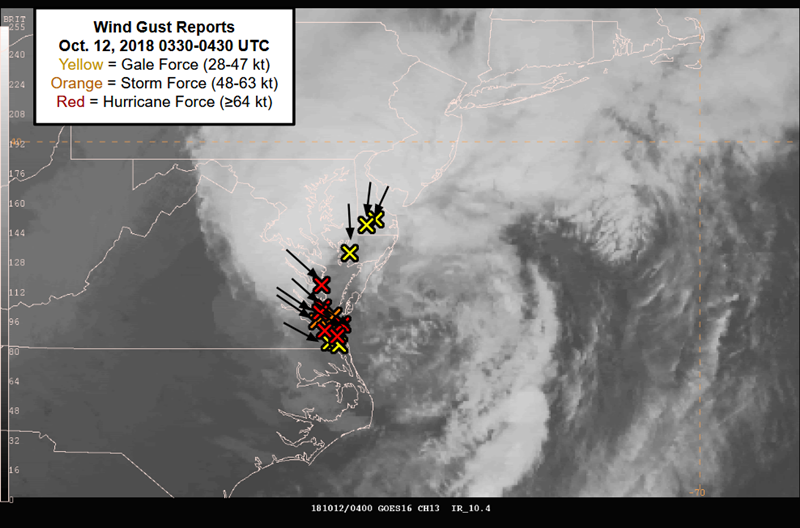
Figure 1:GOES-16 10.3 μm infrared imagery of Michael from 12 October 2018 at 0400 UTC with annotated wind gust reports from 0330-0430 UTC. Yellow indicates gale force wind gusts (28-47 kt); orange indicates storm force wind gusts (48-63 kt); red indicates hurricane force wind gusts (64 kt and stronger).
Researchers from NOAA’s Ocean Prediction Center, University of Maryland College Park, and University of Maryland Baltimore County are investigating the cause of high winds during Michael’s extratropical transition using observations, satellite imagery from NOAA’s GOES-16, and NASA’s MERRA-2 reanalysis. Visual analyses of these data sets can reveal information about the causes of strong winds during Michael’s different stages of extratropical transition. This research pushes the limits of our understanding of sting jets and how to utilize satellite imagery to analyze sting jet occurrences.
 Deirdre Dolan has been researching at NOAA's Ocean Prediction Center for the past 2 1/2 years while working on her undergraduate and graduate research. She was the first student accepted into the 4+1 Bachelor's and Master's combined program for Atmospheric and Oceanic Science at the University of Maryland, College Park. She will graduate with her M.S. this summer. Deirdre Dolan's studies have been supported with funds from CICS and CISESS.
« Back