TROPICS CubeSat Radiances Improve Tropical Storm Forecasts
July 24, 2026 08:30 AM
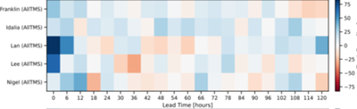
Figure 1: Net forecast improvement (%) from TROPICS assimilation, with positive values (blue) indicating net improvement and negative values (red) indicating degradation.
© Isaac Moradi
By Debra Baker
CISESS Scientist Isaac Moradi has tested data assimilaton of TROPICS CubeSat radiances into the NOAA operational Hurricane Analysis and Forecast System (HAFS). Figure 1 shows the overall impact from TROPICS assimilation on prediction of four hurricanes and one typhoon, with blue indicating improvements and red indicating degradation. According to his 2026 CISESS Annual Report, this work has successfully established TROPICS as a high-value pathfinder mission, offering a clear methodology for leveraging upcoming commercial high-revisit small-satellite constellations to eliminate critical temporal data gaps across the tropical ocean basins.
Moradi’s CISESS Project is “Investigating the Impact of the Assimilation of TMS Observations on the Prediction of Tropical Cyclones,” funded by the NESDIS LEO Program. His work was assisted by NOAA Staff, including Satya Kalluri, Vijay Tallapragada, and Xu Lu as well as William Blackwell from the MIT Lincoln Laboratory, the group that proposed the TROPICS satellites mission.
The Study’s Satellites, Sensors and Model
The satellites used in Moradi’s study are the NASA Time-Resolved Observations of Precipitation structure and storm Intensity with a Constellation of Smallsats (TROPICS) mission. They are an array of CubeSats that measure temperature, humidity, and precipitation (see Figure 2). The passive microwave sounders have spatial resolution similar to existing satellites, but they offer much more frequest observations with their 60-minute revisit time. This kind of temporal resolution is critical for forecasting tropical storms and hurricanes. In fact, tropical cyclone modeling and data assimlation was identified as an Application Focus Area for the TROPICS mission.
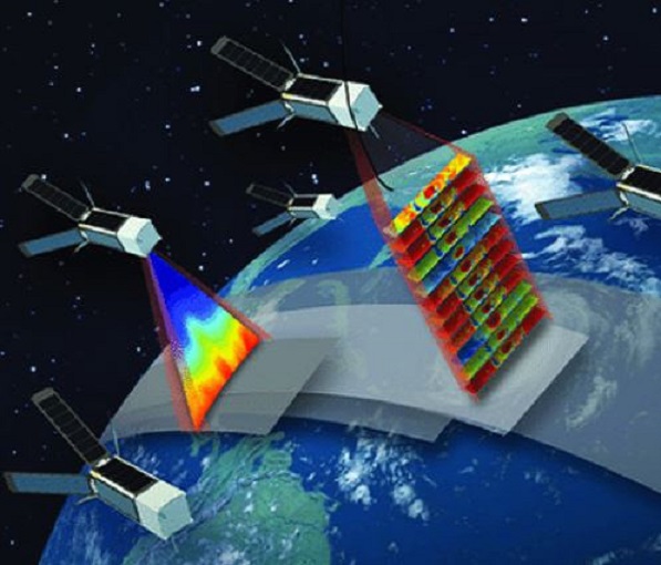
Figure 2: TROPICS Satellites, from NASA Earth Data.
The sensor used in the study is the TROPICS Millimeter-wave Sounder (TMS), a passive microwave radiometer (see Figure 3). It provides observations across a 2200 km swath (distance between the center points of the first and last footprints) with a symmetrical scan pattern (equal number of field of views (FOVs) each side of nadir). It is a cross-track sounder, with elongated footprints in the cross-track direction, so its spatial resolution varies between 17 and 27 km.The instrument observes the Earth and atmosphere with four channels: 118 GHz (oxygen), 183.31 GHz (water vapor), 91.655 GHz (liquid precipitation) and 204.8 GHz (frozen precipitation). Kidd et al., 2022.
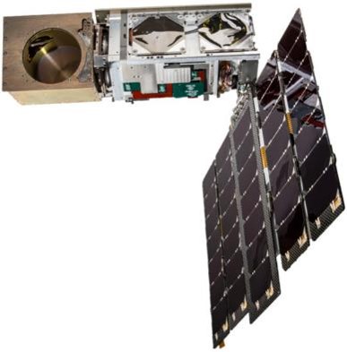
Figure 3: TROPICS CubeSat with the TMS Radiometer on the left, from: Kidd et al., 2022.
The model used in Moradi’s study is the Hurricane Analysis and Forecast System (HAFS) . This is one of the models in the next-generation Unified Forecast System. HAFS is NOAA’s new multi-scale numerical model for tropical storms, hurricanes, and typhoons. It has its own data assimilation package as well as ocean coupling, which has extended the tropical storm forecast out to seven days. It is designed to provide reliable and skillful guidance on hurricane track and intensity (including rapid intensification), storm size, genesis, storm surge, rainfall and tornadoes associated with hurricanes.
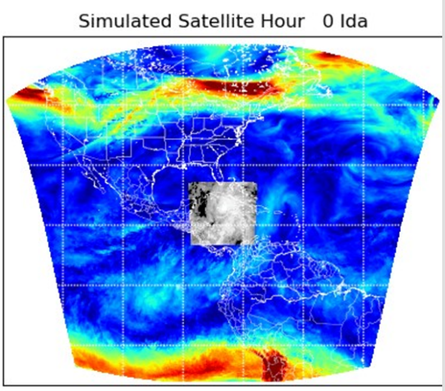
Figure 4: Hurricane Analysis and Forecast System Moving Nest Implementation
Once of the key innovations in the HAFS model is the storm-following grid system (see Figure 4 above). For this work, Moradi took advantage of HAFS’ nested grids. All the model runs had a stationary parent grid (0.027° grid spacing) with a two-way interactive grid moving at cloud-resolving scales (0.009° grid spacing). The goal of this set-up was to be able to resolve inner-core storm dynamics.
The Data Assimilation Framework
The observations from TROPICS most useful for tropical storm prediction are data that describe precipitation structure and storm intensity. However, these products are the result of algorithm retrieval methods, which bring in their own biases and uncertainty. Instead, Moradi chose to directly assimilate clear-sky TMS radiances – the raw output of the satellites, often called Sensor Data Records (SDRs) at NOAA. Sometimes observations were missing due to inactive satellites in the array.
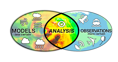
Figure 5: Data assimilation is the process of converting observations into an analysis that can be used to update a model’s fields. The data is often diverse, sampled at different times and intervals and different locations, and data assimilation turns it into a unified and consistent description of a physical system, such as the state of the atmosphere.
To keep the experiment as close to operational conditions as possible, the project used NOAA’S Global Data Assimilation System (GDAS). GDAS is the system used for the Global Forecast System (GFS) model to place observations into a gridded model space for the purpose of starting, or initializing, weather forecasts with observed data. GDAS is a hybrid of 4DEnsVar and GSI. The 4DVar indicates that the input can be varied in any of the three spatial directions and the 4th dimension, which is time. The “EnsVar” indicates that it is uses an ensemble of model runs to estimate forecast errors. For GDAS, this ensemble has 80 members. GSI stands for gridpoint statistical interpolation and it places the observations on specific gridpoints, which allows the model to use parallel processing to improve efficiency.
Bias Correction
The major obstacle to successful data assimilation of TROPICS data was the pronounced scan-angle bias. Observed-minus-forecast (OMF) statistics derived via the NOAA global model indicated biases ranging from -1.0 K to -2.0 K for surface-sensitive window channels at nadir, expanding up to -5.0 K at extreme satellite zenith angles for several spacecraft (see Figure 6). Atmospheric humidity sounder channels around the 183 GHz band also showed systematic biases exceeding -1.0 K. This was due to the innovative noise-diode calibration mechanism, which was different from the traditional cold-space/hot-target calibration.
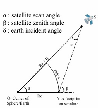
Figure 6: Definition of a satellite scan angle and satellite zenith angle, from CIRA.
Moradi chose Variational Bias Correction (VarBC) to address this problem. He established optimal VarBC coefficients based on global model statistics–this was a “foundational step” in the project. By porting global model VarBC coefficients into the regional HAFS domain, OMF differences were dramatically suppressed to within ±0.2–0.3 K for most channels, effectively mitigating scan-angle-dependent biases.
Moradi also developed strict quality control protocols, applying a clear-sky scattering index threshold of 10.0 K prior to bias correction and a rigorous 3.0 K observed-minus-forecast (OMF) statistic limit post-correction to isolate robust clear-sky radiances over ocean surfaces.
Project Results.
The goal of this CISESS project was to evaluate the predictive added-value of high-refresh Millimeter-wave Sounder (TMS) observations. This was done using robust numerical experiments. Parallel forecast cycles compared a control run (CTRL), mirroring the operational baseline, against an experimental framework (AllTMS) that incorporated clear-sky TMS radiances from all active constellation satellites.
The two model variables that were tracked were:
-
tropical cyclone track; and
-
maximum sustained wind speed.
The model runs were chosen from the database of 2023 tropical cyclones and included Hurricanes Franklin (see Figure 7), Idalia, Lee, and Nigel, as well as Typhoon Lan in the West Pacific.
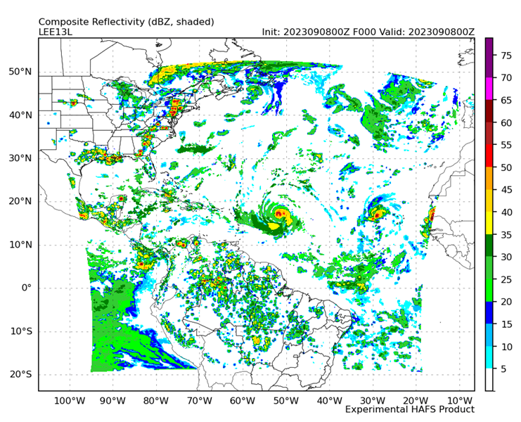 Figure 7: This map shows the HAFS parent domain for Hurricane Franklin along with the simulated radar reflectivity for the analysis on Sept 8, 2023 at 00 UTC.© Isaac Moradi.
Net forecast improvement (%) from TROPICS assimilation is defined as 100 times (n Improved minus n Degraded) divided by (n Improved plus n Degraded). This metric quantifies the overall impact of assimilating TROPICS observations by comparing forecasts that improve versus those that degrade (see Figure 1 at the top).
Statistical evaluation showed that adding rapid-refresh TROPICS observations significantly enhanced predictive accuracy.
-
Tropical Cyclone Tracks: Track error were not reduced within the first 72 hours but had statistically significant reductions at Days 4 and 5, particularly for Hurricanes Idalia and Typhoon Lan.
-
Tropical Cyclone Intensity: The intensity metrics did improve a substantially greater number of forecasts during the entire storm lifetime.
-
Rapid Intensification: During periods of rapid intensification (the jump of Hurricane Lee to Category 4 and the quick strengthening of Hurricane Franklin), the runs with TROPICS data assimilation accurately captured inner-core moisture transport and minimized Extreme Peak Wind Speed underestimation errors by stabilizing the model core (see Figure 8).
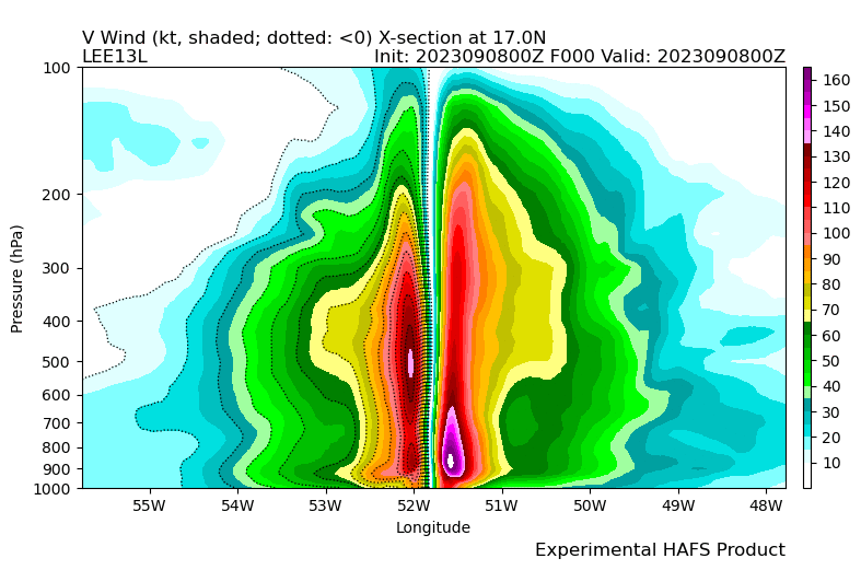
Figure 8: This figure shows the vertical wind profiles for Hurricane Franklin simulated by the HAFS Control Run on the left and by the HAFS Experimental Run assimilaring the TROPICS data for the analysis on Sept 8, 2023 at 00 UTC.© Isaac Moradi.
Moradi analyzed the results and found that the inner-core thermodynamic structures revealed that assimilating TROPICS measurements directly improved vertical temperature and wind symmetry. Cross-sectional profiles for Hurricane Lee and Hurricane Franklin demonstrated that warm-core anomalies (peaking over 14.0 K) extended vertically into higher altitudes with tighter coherence, narrowing the storm eye and expanding symmetric primary circulations compared to the unassimilated baseline (see Figure 8 above). In addition, total column cloud and precipitation water analyses aligned more closely with observations.
There are several elements combined in this study that make this result the “first of its kind:”
-
Use of CubeSat constellation data;
-
Direct assimilation of radiances;
-
High temporal-resolution observations;
-
Assimilation of data on storm structure and intensification; and
-
Modeling within an operational framework.
Moradi has one publication is out on this work in the Journal of Geophysical Research: Atmospheres and another manuscript is awaiting journal approval. He also has produced two products:
1. Numerical Model Development: Enhanced Gridpoint Statistical Interpolation (GSI) to ingest and process 12-channel TROPICS Millimeter-wave Sounder (TMS) clear-sky radiances within the inner moving nested domain of the Hurricane Analysis and Forecast System.
2. Algorithm Development: Ported and verified unified Global Data Assimilation System (GDAS) Variational Bias Correction (VarBC) coefficient look-up coefficients customized for TROPICS constellations (TS-01, TS-03, TS-05, TS-06).
Source
Isaac Moradi 2026 CISESS Annual Report and Slide for Investigating the Impact of the Assimilation of TMS Observations on the Prediction of Tropical Cyclones.
Other Sources
Moradi, Isaac; Satya Kalluri, Vijay Tallapragada, and Yanqiu Zhu, 2026. Sensitivity of tropical cyclone forecasts to the loss of low Earth orbit satellite observations. J. Geophys. Res. Atmos., 131(9), e2026JD046562, https://doi.org/10.1029/2026JD046562.
Moradi, Isaac, 2025: The Role of LEO Observations in Enhancing Tropical Cyclone Prediction. Satellite Book Club Seminar Series, Virtual, February 2025, NOAA National Weather Service (NWS) Office of Observations. [Virtual Oral Presentation]
Moradi, Isaac, Satya Kalluri, Vijay Tallapragada, Xu Lu, and Flavio Iturbide-Sanchez, 2026: Assimilation of Microwave Observations from CubeSats into NOAA HAFS Model. AMS Annual Meeting, Houston, TX, January 25-29, 2026, American Meteorology Society.[Oral Presentation]
Moradi, Isaac, Yanqiu Zhu, Satya Kalluri, and Ricardo Todling, 2026: Advancing Assimilation of Microwave and Radar Observations in the NWP Models. EGU General Assembly 2026, Vienna, Austria, May 3–8, 2026, European Geosciences Union. [Oral Presentation]
Moradi, Isaac, Yanqiu Zhu, Satya Kalluri, Benjamin Ruston, and Ricardo Todling., 2026: Enhancing the Assimilation of Microwave and Radar Observations in NWP Models for Improved Tropical Cyclone Prediction. 37th AMS Conference on Hurricanes and Tropical Meteorology, San Diego, CA, March 30 to April 3, 2026, American Meteorology Society.[Oral Presentation]
Kidd, Chris, Toshi Matsui, William Blackwell, Scott Braun, Robert Leslie, and Zach Griffith, 2022. Precipitation estimation from the NASA TROPICS mission: Initial retrievals and validation" Remote Sens., 14(13), 2992, https://doi.org/10.3390/rs14132992.
*Bold-CISESS & Underline-NOAA
« Back