LEO vs. GEO Satellite Tropospheric NOx Measurements
March 20, 2026 12:00 PM
Journal of Geophysical Research Atmospheres
© AGU
By Maureen Cribb, CISESS Coordinator
CISESS Consortium Scientist Fangjun Li (South Dakota State University) is a co-author on a new study of space-based measurements of ground NOx in the United States, published in the Journal of Geophysical Research: Atmospheres. The amount of nitrogen oxides [NOx, defined as the sum of nitric oxide and nitrogen dioxide (NO2)] in the atmosphere can be used as a proxy for tropospheric ozone air pollution since it is a key precursor to O3. NOx also affects human health and has certain detrimental effects on the environment.
Ground-based in-situ measurements are one way of monitoring NOx levels, but these are point measurements, and monitoring stations making these measurements are sparsely distributed around the world. Remote sensing from space is a way to get around this problem. Over the past decades, a number of NOx-monitoring instruments have been deployed on low Earth orbit (LEO) satellites, such as the TROPOspheric Monitoring Instrument (TROPOMI). However, even though there is global coverage, retrievals are typically made only once a day.
Enter recently developed geostationary (GEO) satellite instruments like Tropospheric Emissions: Monitoring of Pollution (TEMPO) measuring NOx hourly at a higher spatial resolution. In their paper, Li and his colleagues explore the benefit of using TEMPO (GEO) NO2 data for NOx emission estimates compared to TROPOMI (LEO). The model they used to estimate NOx emissions is the Weather Research and Forecasting Model with the Chemistry/Data Assimilation Research Testbed (WRF-Chem/DART), and the selected period of study is August 2023.
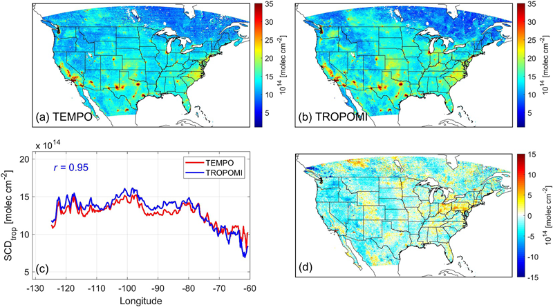
Figure1: (a) Average TEMPO NO2 tropospheric slant column density (SCD), (b) Average TROPOMI NO2 tropospheric SCDs, (c) Meridionally aggregated NO2 tropospheric SCD, and (d) TEMPO minus TROPOMI tropospheric SCD.
The authors present promising results, first showing that top-down NOx emissions derived from midday TEMPO and TROPOMI data were similar over urban regions. These top-down measurements were lower than bottom‐up NOx emissions obtained from 2021 GReenhouse gas And Air Pollutants Emissions System (GRA2PES) by 5–20%, but agreed better with the updated 2023 GRA2PES emissions. The general conclusion is that TEMPO midday data can better track and infer NOx sources than TROPOMI's once‐daily measurements. They do note that there are inherent data biases requiring a further look into but that overall, high‐resolution hourly monitoring from TEMPO will greatly advance the tracking and understanding of air pollution, leading to more effective emissions mitigation strategies.
Citation: Hsu, Chia‐Hua, Daven K. Henze, Arthur P. Mizzi, Colin Harkins, Congmeng Lyu, Owen R. Cooper, Rebecca H. Schwantes, Jian He, Meng Li, Siyuan Wang, Chelsea E. Stockwell, Carsten Warneke, Andrew W. Rollins, Eleanor M. Waxman, Kristen Zuraski, Jeff Peischl, Shobha Kondragunta, Fangjun Li, Chuanyu Xu, R. Bradley Pierce, Gonzalo Gonzalez Abad, Caroline R. Nowlan, Xiong Liu, and Brian C. McDonald, 2026: Top‐down estimates of U.S. NOx emissions using TEMPO and TROPOMI NO2 remote sensing observations with WRF‐Chem/Chem‐DART. J. Geophys. Res.: Atmos., 131(2), e2025JD044223, https://doi.org/10.1029/2025JD044223.
« Back