Radar Altimetry Advances for Ocean Observations
February 20, 2026 12:48 PM
by Maureen Cribb, CISESS Coordinator
On 12 February 2026, CISESS Scientist Christopher Buchhaupt gave a talk titled “Advances in Radar Altimetry for Observing Sea State and Sea Level” as part of the STAR Science Seminar Series, attended by 30 people. Since 2010, a new generation of space-based ocean observations has significantly improved the monitoring of the ocean surface, providing more detailed measurements of sea-state and sea level, and making it easier to capture changes in ocean conditions, particularly in coastal and high-energy regions. Those observations play an important role in weather and ocean forecasting, long-term assessments of ocean conditions, and studies of how waves and sea level influence coastal, reef, and offshore environments. Buchhaupt introduced new parameters related to wave motion, i.e., standard deviation of vertical wave velocities and mean line-of-sight velocity, enabled by recently developed SAR algorithms. Among the results, the novel SAR altimetry algorithm described by Buchhaupt provides consistent significant wave heights (left panel of the figure). Another interesting result is the first known demonstration of the potential of estimating snow depths from a single-frequency radar altimeter (right panel of the figure).
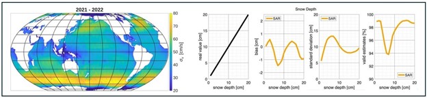
Figure 1: (Left) Two-year averaged Sentinel-6MF Low Resolution Mode SAR standard deviations of vertical wave velocities over the open ocean retrieved with the novel SAR algorithm. (Right) Snow-depth statistics from SAR altimetry.
« Back